IMAGES TAKEN NEAR TO
Radcliffe Park Crescent, SALFORD, M6 7WQ
Introduction
This page details the photographs taken nearby to Radcliffe Park Crescent, M6 7WQ by members of the Geograph project.
The Geograph project started in 2005 with the aim of publishing, organising and preserving representative images for every square kilometre of Great Britain, Ireland and the Isle of Man.

There are currently over 7.5m images from over14,400 individuals and you can help contribute to the project by visiting https://www.geograph.org.uk
Image Map
Images are licensed for reuse under creativecommons.org/licenses/by-sa/2.0
Notes
- Clicking on the map will re-center to the selected point.
- The higher the marker number, the further away the image location is from the centre of the postcode.
Image Listing (8 Images Found)
Images are licensed for reuse under creativecommons.org/licenses/by-sa/2.0
Image
Details
Distance
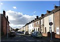
2
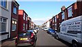
New Barton Street, Irlam o'th' Heights
A view down New Barton Street in the Irlam o'th' Heights area of the City of Salford, in Greater Manchester, England.
Image: © Steven Haslington
Taken: 7 Sep 2016
0.15 miles
3
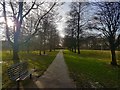
Path in Oakwood Park
Lancaster Road is the road in the background.
Image: © Bradley Michael
Taken: 24 Jan 2018
0.19 miles
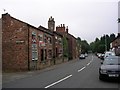
5
Stapleton Street
Off Claremount Road.
Image: © Gerald England
Taken: 27 Oct 2017
0.22 miles
6
Irlams o' th' Height
Looking in a southerly direction down Claremont Road in Irlams o' th' Height, Salford. SD79470045
Image: © Keith Williamson
Taken: 5 Sep 2005
0.22 miles
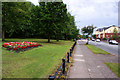
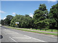
7

Lancaster Road, Salford
Looking NE on Lancaster Road towards its junction with the East Lancashire Road in the distance. The parkland visible is that of Oakwood Park. SD78750050
Image: © Keith Williamson
Taken: 5 Sep 2005
0.23 miles
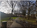
8
Oakwood Park, Lancaster Road, Salford
Image: © Anthony Parkes
Taken: 21 Jul 2010
0.25 miles