IMAGES TAKEN NEAR TO
Duchy Road, SALFORD, M6 7JS
Introduction
This page details the photographs taken nearby to Duchy Road, M6 7JS by members of the Geograph project.
The Geograph project started in 2005 with the aim of publishing, organising and preserving representative images for every square kilometre of Great Britain, Ireland and the Isle of Man.

There are currently over 7.5m images from over14,400 individuals and you can help contribute to the project by visiting https://www.geograph.org.uk
Image Map
Images are licensed for reuse under creativecommons.org/licenses/by-sa/2.0
Notes
- Clicking on the map will re-center to the selected point.
- The higher the marker number, the further away the image location is from the centre of the postcode.
Image Listing (10 Images Found)
Images are licensed for reuse under creativecommons.org/licenses/by-sa/2.0
Image
Details
Distance
1
Soon to be not of this world
Egmont Street, Salford 6, all boarded up and ready for demolition.
Image: © Alexander P Kapp
Taken: 5 Feb 2008
0.13 miles
2
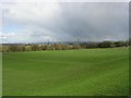
Bolton Road Playing Fields
Situated in Brindle Heath, Salford. Looking NE, across the Irwell valley.
Image: © Keith Williamson
Taken: 8 Apr 2005
0.20 miles
3
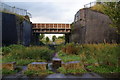
Path under the railway
This is an extension of Bank Lane, but vehicles are clearly prevented from going any further. The railway runs between Manchester and Bolton and has been reduced in size.
Image: © Bill Boaden
Taken: 18 Sep 2012
0.22 miles
4
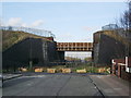
Road block
At the end of Bank Lane, Salford 6
Image: © Alexander P Kapp
Taken: 5 Feb 2008
0.23 miles
5
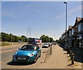
Bolton Road
The former A6 through Irlam o'th' Heights now bypassed for non-local traffic by the dual carriageway on the left.
Image: © Gerald England
Taken: 27 Jun 2019
0.23 miles
6
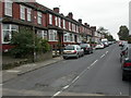
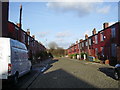
Brindle Heath, Moorfield Road
Terraced housing off Bolton Road.
Image: © Mike Faherty
Taken: 18 Oct 2009
0.23 miles
7
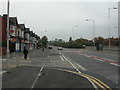
Brindle Heath, roads
In the centre, Bolton Road, the original A6 before Broad Street, behind the barrier to the right, was built.
Image: © Mike Faherty
Taken: 18 Oct 2009
0.24 miles
8
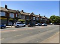
Shops at Irlam o'th' Heights
A row of shops on Bolton Road, the former A6. It includes a newsagents, laundry, motor spares shop, a branch of Subway, a barbers and some others.
Image: © Gerald England
Taken: 27 Jun 2019
0.24 miles
9
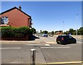
Junction of Bolton Road and Doveleys Road
Bolton Road is the former A6 through Irlam o'th' Heights now bypassed for non-local traffic by the dual carriageway on the right.
Image: © Gerald England
Taken: 27 Jun 2019
0.25 miles
