IMAGES TAKEN NEAR TO
Ridsdale Walk, SALFORD, M6 6SA
Introduction
This page details the photographs taken nearby to Ridsdale Walk, M6 6SA by members of the Geograph project.
The Geograph project started in 2005 with the aim of publishing, organising and preserving representative images for every square kilometre of Great Britain, Ireland and the Isle of Man.

There are currently over 7.5m images from over14,400 individuals and you can help contribute to the project by visiting https://www.geograph.org.uk
Image Map
Images are licensed for reuse under creativecommons.org/licenses/by-sa/2.0
Notes
- Clicking on the map will re-center to the selected point.
- The higher the marker number, the further away the image location is from the centre of the postcode.
Image Listing (28 Images Found)
Images are licensed for reuse under creativecommons.org/licenses/by-sa/2.0
Image
Details
Distance
1
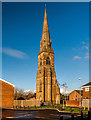
St George
St George Church Spire at Charlestown.
Image: © Peter McDermott
Taken: 22 Nov 2014
0.05 miles
2
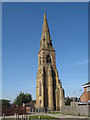
St George, Charlestown
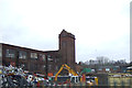
The C of E church of St George, Charlestown was founded in 1858 and closed in 1993 moving to a new building on Douglas Green (which also closed in 2006). The body of the church has been demolished, leaving this lovely spire standing proudly above the local community.
Image: © Sue Adair
Taken: 20 Sep 2008
0.08 miles
3
A steeple without a church
The steeple is all that remains. From the street names around, the church would have been St George's
Image: © Ian Greig
Taken: 12 Aug 2010
0.08 miles
4
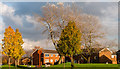
Charlestown
Houses at Charlestown near Pendleton in Salford.
Image: © Peter McDermott
Taken: 22 Nov 2014
0.16 miles
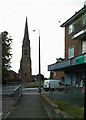
6
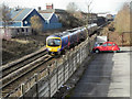
Manchester To Bolton Railway Line
Manchester-bound train approaching the bridge at Broughton Road. The car park (and the bushes beyond) on the right hand side of this photo are on the site of the former Manchester, Bolton & Bury Canal.
Image: © David Dixon
Taken: 24 Feb 2011
0.16 miles
7
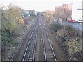
Pendleton Bridge railway station (site), Greater Manchester
Opened in 1838 by the Manchester & Bolton Railway, later to be part of the Lancashire & Yorkshire Railway, this station closed in 1966.
View north west towards Clifton Junction and Bolton. The main building was to the left, whilst immediately to the right of the right-hand-platform was a canal. No trace of any of these features remain.
Image: © Nigel Thompson
Taken: 17 Nov 2012
0.18 miles
8
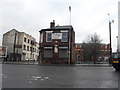
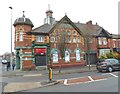
Former Pendleton Co-operative building at Charlestown
Image: © John Slater
Taken: 14 Mar 2015
0.21 miles
10
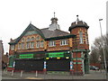
Historic Co-op building
Littleton Road / Cromwell Road
Image: © Anthony O'Neil
Taken: 15 Feb 2020
0.21 miles