IMAGES TAKEN NEAR TO
Trentham Lawns, SALFORD, M6 6QN
Introduction
This page details the photographs taken nearby to Trentham Lawns, M6 6QN by members of the Geograph project.
The Geograph project started in 2005 with the aim of publishing, organising and preserving representative images for every square kilometre of Great Britain, Ireland and the Isle of Man.

There are currently over 7.5m images from over14,400 individuals and you can help contribute to the project by visiting https://www.geograph.org.uk
Image Map
Images are licensed for reuse under creativecommons.org/licenses/by-sa/2.0
Notes
- Clicking on the map will re-center to the selected point.
- The higher the marker number, the further away the image location is from the centre of the postcode.
Image Listing (40 Images Found)
Images are licensed for reuse under creativecommons.org/licenses/by-sa/2.0
Image
Details
Distance
2
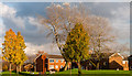
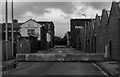
Charlestown
Houses at Charlestown near Pendleton in Salford.
Image: © Peter McDermott
Taken: 22 Nov 2014
0.05 miles
3
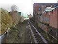
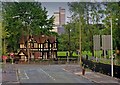
Manchester To Bolton Railway Line
Looking towards Manchester along the Manchester to Bolton railway line from the bridge at Broughton Road. Although there is little (if anything) left to show, the Manchester, Bolton & Bury Canal used to run alongside the railway (on the left hand side in this view)
Image: © David Dixon
Taken: 24 Feb 2011
0.11 miles
4
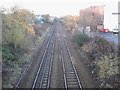
Pendleton Bridge railway station (site), Greater Manchester
Opened in 1838 by the Manchester & Bolton Railway, later to be part of the Lancashire & Yorkshire Railway, this station closed in 1966.
View north west towards Clifton Junction and Bolton. The main building was to the left, whilst immediately to the right of the right-hand-platform was a canal. No trace of any of these features remain.
Image: © Nigel Thompson
Taken: 17 Nov 2012
0.15 miles
5
Cheltenham Street
Cheltenham Street in Pendleton.
Image: © Peter McDermott
Taken: 12 Nov 2016
0.16 miles
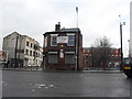
6
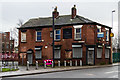
The Railway
The Railway public house.
Image: © Peter McDermott
Taken: 31 Dec 2014
0.16 miles
7
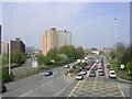
Broad Street, Salford
In the 1960's and 70's, massive slum clearance and redevelopment re-shaped this area. Broad Street used to be a street with many traditional shops surrounded by street upon street of terraced housing from Victorian times. Now it is a busy thoroughfare into Salford and central Manchester. Taken from SJ 815 990.
Image: © Keith Williamson
Taken: 22 Apr 2005
0.16 miles
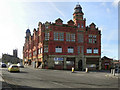
8
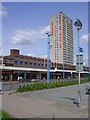
Pendleton Shopping Centre
Opened in the early 1970's following slum clearances of the late 60's
Image: © Keith Williamson
Taken: 11 May 2005
0.16 miles
9
Broughton Road and Frederick Road Junction
Broughton Road and Frederick Road Junction where the Gatehouse is to David Lewis Playing Fields.
Image: © Edward Smith
Taken: 15 Jul 2008
0.17 miles
10
Former Pendleton Co-operative Building
Formerly Pendleton Co-operative Industrial Society building on Broughton Road (datestone says 1886 - see Image). Now converted into apartments.
Image: © David Dixon
Taken: 24 Feb 2011
0.17 miles