IMAGES TAKEN NEAR TO
Stan Mellor Close, M6 6QB
Introduction
This page details the photographs taken nearby to Stan Mellor Close, M6 6QB by members of the Geograph project.
The Geograph project started in 2005 with the aim of publishing, organising and preserving representative images for every square kilometre of Great Britain, Ireland and the Isle of Man.

There are currently over 7.5m images from over14,400 individuals and you can help contribute to the project by visiting https://www.geograph.org.uk
Image Map
Images are licensed for reuse under creativecommons.org/licenses/by-sa/2.0
Notes
- Clicking on the map will re-center to the selected point.
- The higher the marker number, the further away the image location is from the centre of the postcode.
Image Listing (60 Images Found)
Images are licensed for reuse under creativecommons.org/licenses/by-sa/2.0
Image
Details
Distance
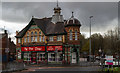
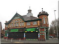
2
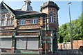
Derelict Co-operative Shop - Gerald Road Salford
Image: © Anthony Parkes
Taken: 24 May 2010
0.09 miles
4

The Pavilion
The Pavilion, part of Salford University's Student Village.
Image: © Peter McDermott
Taken: 28 Aug 2016
0.09 miles
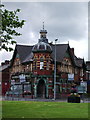
6
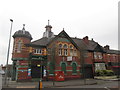
Former Pendleton Co-operative building at Charlestown
Image: © John Slater
Taken: 14 Mar 2015
0.10 miles
7
Charlestown
The former Pendleton Co-operative building in Charlestown.
Image: © Peter McDermott
Taken: 12 Nov 2016
0.10 miles
8
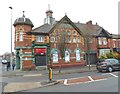
Historic Co-op building
Littleton Road / Cromwell Road
Image: © Anthony O'Neil
Taken: 15 Feb 2020
0.10 miles
9
Former Pendleton Co-operative building at Charlestown
Image: © John Slater
Taken: 14 Mar 2015
0.11 miles