IMAGES TAKEN NEAR TO
Gloucester Place, SALFORD, M6 6PR
Introduction
This page details the photographs taken nearby to Gloucester Place, M6 6PR by members of the Geograph project.
The Geograph project started in 2005 with the aim of publishing, organising and preserving representative images for every square kilometre of Great Britain, Ireland and the Isle of Man.

There are currently over 7.5m images from over14,400 individuals and you can help contribute to the project by visiting https://www.geograph.org.uk
Image Map
Images are licensed for reuse under creativecommons.org/licenses/by-sa/2.0
Notes
- Clicking on the map will re-center to the selected point.
- The higher the marker number, the further away the image location is from the centre of the postcode.
Image Listing (67 Images Found)
Images are licensed for reuse under creativecommons.org/licenses/by-sa/2.0
Image
Details
Distance
1
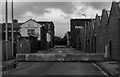
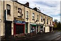
Cheltenham Street
Cheltenham Street in Pendleton.
Image: © Peter McDermott
Taken: 12 Nov 2016
0.05 miles
2
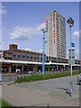
Pendleton Shopping Centre
Opened in the early 1970's following slum clearances of the late 60's
Image: © Keith Williamson
Taken: 11 May 2005
0.06 miles
3
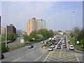
Broad Street, Salford
In the 1960's and 70's, massive slum clearance and redevelopment re-shaped this area. Broad Street used to be a street with many traditional shops surrounded by street upon street of terraced housing from Victorian times. Now it is a busy thoroughfare into Salford and central Manchester. Taken from SJ 815 990.
Image: © Keith Williamson
Taken: 22 Apr 2005
0.06 miles
4

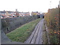
Pendleton station - platform view
One of the hourly Blackburn-Manchester trains is calling. This was part of the "new Liverpool line" of the former Lancashire and Yorkshire Railway, with four tracks throughout from Manchester Victoria to west of Wigan Wallgate (including the Wigan loop), most stations having two island platforms as here.
Image: © Peter Whatley
Taken: Unknown
0.08 miles
5
Broad Street
Buildings on Broad Street in Pendleton, Salford.
Image: © Peter McDermott
Taken: 12 Nov 2016
0.08 miles
6
Pendleton Broad Street railway station (site), Greater Manchester
Opened in 1888 by the Lancashire & Yorkshire Railway on its line from Manchester to Wigan, and closed in 1998 as it was superseded by Salford Crescent station. View north west towards Wigan Wallgate - the main building was attached to the next overbridge.
Image: © Nigel Thompson
Taken: 17 Nov 2012
0.09 miles
7
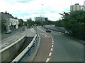
The underpass on Broad Street in Salford
View from sliproad off roundabout over the underpass
Image: © Raymond Knapman
Taken: 24 Jun 2011
0.09 miles
8
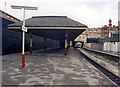
Pendleton station
Pendleton once had two stations, about 100 yards apart on the same main road. Originally Pendleton Broad Street, this was the survivor in the 1980s, with services to Blackburn, Wigan and Manchester. There was a second, identical double-sided platform on the right at one time. Pendleton was so close to Salford Crescent that it closed shortly after that station was opened.
Image: © Peter Whatley
Taken: 4 Mar 1989
0.10 miles
10

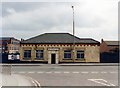
Pendleton station - exterior view
In 1977, an hourly service called here en route from Manchester to Blackburn, using a chord between the Wigan and Bolton routes now dismantled completely. Some Wigan services also called.
Image: © Peter Whatley
Taken: Unknown
0.10 miles