IMAGES TAKEN NEAR TO
Grandstand Avenue, SALFORD, M6 6NJ
Introduction
This page details the photographs taken nearby to Grandstand Avenue, M6 6NJ by members of the Geograph project.
The Geograph project started in 2005 with the aim of publishing, organising and preserving representative images for every square kilometre of Great Britain, Ireland and the Isle of Man.

There are currently over 7.5m images from over14,400 individuals and you can help contribute to the project by visiting https://www.geograph.org.uk
Image Map
Images are licensed for reuse under creativecommons.org/licenses/by-sa/2.0
Notes
- Clicking on the map will re-center to the selected point.
- The higher the marker number, the further away the image location is from the centre of the postcode.
Image Listing (61 Images Found)
Images are licensed for reuse under creativecommons.org/licenses/by-sa/2.0
Image
Details
Distance
2
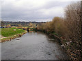
River Irwell
Downstream from Littleton Bridge.
Image: © David Dixon
Taken: 8 Apr 2010
0.08 miles
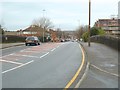
3
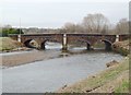
Littleton Bridge
Charlestown, Salford
Image: © Anthony O'Neil
Taken: 15 Feb 2020
0.10 miles
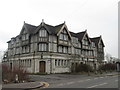
5
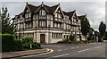
The Racecourse Hotel
Very grand and rather tired looking public house.
Image: © Peter McDermott
Taken: 28 Aug 2016
0.11 miles
6
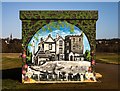
Kersal Wetlands
Mural on building at the Kersal Wetlands.
Image: © Peter McDermott
Taken: 3 Jan 2020
0.11 miles
7
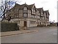
The Racecourse Hotel
Public house on Littleton Road.
Image: © David Dixon
Taken: 8 Apr 2010
0.11 miles
8
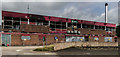
The Pavilion
The Pavilion, part of Salford University's Student Village.
Image: © Peter McDermott
Taken: 28 Aug 2016
0.11 miles
10
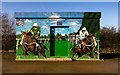
Kersal Wetlands
Mural on building at the Kersal Wetlands.
Image: © Peter McDermott
Taken: 3 Jan 2020
0.12 miles