IMAGES TAKEN NEAR TO
Capricorn Way, SALFORD, M6 6HD
Introduction
This page details the photographs taken nearby to Capricorn Way, M6 6HD by members of the Geograph project.
The Geograph project started in 2005 with the aim of publishing, organising and preserving representative images for every square kilometre of Great Britain, Ireland and the Isle of Man.

There are currently over 7.5m images from over14,400 individuals and you can help contribute to the project by visiting https://www.geograph.org.uk
Image Map
Images are licensed for reuse under creativecommons.org/licenses/by-sa/2.0
Notes
- Clicking on the map will re-center to the selected point.
- The higher the marker number, the further away the image location is from the centre of the postcode.
Image Listing (53 Images Found)
Images are licensed for reuse under creativecommons.org/licenses/by-sa/2.0
Image
Details
Distance
1

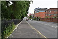
Frederick Road, Salford
A useful road to avoid the city centre. This view used to be dominated by a bus depot, but that has now been replaced by the new buildings.
Image: © Bill Boaden
Taken: 21 Jan 2012
0.06 miles
3
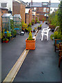
Secret gardens of Welford Street (East)
The regeneration of Charlestown resulted in Welford Street's alley gates, and a communal patio and potted garden appearing in the back alley.
Image: © Salford Sal
Taken: 28 Jul 2009
0.08 miles
4
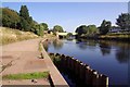
Towards Wallnes Bridge
The Image and River Irwell
Image: © Glyn Baker
Taken: 31 Aug 2018
0.08 miles
5
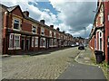
Welford Street
Terraced housing with cobbled road, the stereotype for Salford
Image: © Kevin Waterhouse
Taken: 4 Jul 2023
0.08 miles
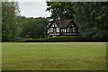
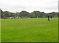
6
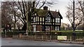
David Lewis Sports Ground
House at the edge of The Palatine Inn in Salford.
Image: © Peter McDermott
Taken: 31 Dec 2014
0.09 miles
8
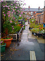
Secret gardens of Welford Street (west)
The secret gardens in the back alleys of Welford Street have existed for many years, but were limited to permanent structures, difficult to steal or vandalise. The regeneration of Charlestown resulted in Welford Street's alley gates, which allowed an existing gardening community to flourish, particularly to the west end of the street.
Image: © Salford Sal
Taken: 28 Jul 2009
0.09 miles
9
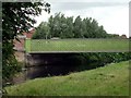
Bridge, Salford
Carries the B6186 over the River Irwell. A sign on the bridge dates it 1880 but doesn't give it a name.
Image: © Graham Hogg
Taken: 5 Jul 2010
0.09 miles
10
Salford, recreation ground
David Lewis Recreation Ground, off Frederick Road: https://www.salford.ac.uk/studentchannel/news/david-lewis-playing-fields-added-to-our-sports-portfolio
Image: © Mike Faherty
Taken: 22 Sep 2019
0.09 miles