IMAGES TAKEN NEAR TO
Park View Road, SALFORD, M6 6GY
Introduction
This page details the photographs taken nearby to Park View Road, M6 6GY by members of the Geograph project.
The Geograph project started in 2005 with the aim of publishing, organising and preserving representative images for every square kilometre of Great Britain, Ireland and the Isle of Man.

There are currently over 7.5m images from over14,400 individuals and you can help contribute to the project by visiting https://www.geograph.org.uk
Image Map
Images are licensed for reuse under creativecommons.org/licenses/by-sa/2.0
Notes
- Clicking on the map will re-center to the selected point.
- The higher the marker number, the further away the image location is from the centre of the postcode.
Image Listing (36 Images Found)
Images are licensed for reuse under creativecommons.org/licenses/by-sa/2.0
Image
Details
Distance
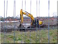
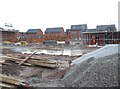
1
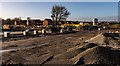
Charlestown
New housing at Charlestown.
Image: © Peter McDermott
Taken: 3 Jan 2020
0.07 miles
5
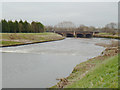
Weir and Road Bridge
Charlestown, Salford
Image: © Anthony O'Neil
Taken: 15 Feb 2020
0.12 miles
6
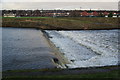
Weir on the River Irwell
Beyond is Lower Kersal and Littleton Road Playing Fields.
Image: © Bill Boaden
Taken: 21 Jan 2012
0.12 miles
7
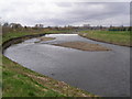
River Irwell
Upstream from Littleton Road
Image: © David Dixon
Taken: 8 Apr 2010
0.13 miles
8
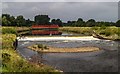
River Irwell
Weir and footbridge crossing the River Irwell.
Image: © Peter McDermott
Taken: 28 Aug 2016
0.13 miles
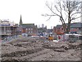
9
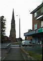
A steeple without a church
The steeple is all that remains. From the street names around, the church would have been St George's
Image: © Ian Greig
Taken: 12 Aug 2010
0.13 miles
10
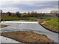
River Irwell
Weir and the Jubilee Foot Bridge.
Image: © David Dixon
Taken: 8 Apr 2010
0.13 miles