IMAGES TAKEN NEAR TO
Gerald Road, SALFORD, M6 6EG
Introduction
This page details the photographs taken nearby to Gerald Road, M6 6EG by members of the Geograph project.
The Geograph project started in 2005 with the aim of publishing, organising and preserving representative images for every square kilometre of Great Britain, Ireland and the Isle of Man.

There are currently over 7.5m images from over14,400 individuals and you can help contribute to the project by visiting https://www.geograph.org.uk
Image Map
Images are licensed for reuse under creativecommons.org/licenses/by-sa/2.0
Notes
- Clicking on the map will re-center to the selected point.
- The higher the marker number, the further away the image location is from the centre of the postcode.
Image Listing (76 Images Found)
Images are licensed for reuse under creativecommons.org/licenses/by-sa/2.0
Image
Details
Distance
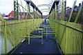
3
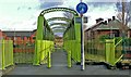
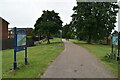
Gerald Road Footbridge
Gerald Road Footbridge crosses the River Irwell and connects Pendleton to Lower Broughton
Image: © Edward Smith
Taken: 10 Jan 2007
0.09 miles
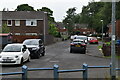
5
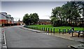
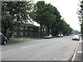
Gerald Road
Gerald Road and the Albion Green on Albion Estate where the Albion Dog Track once stood.
Image: © Edward Smith
Taken: 9 Jun 2009
0.09 miles
6
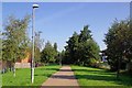
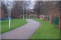
Irwell Riverside Walk
The walk and the Image run together here.
Image: © Glyn Baker
Taken: 31 Aug 2018
0.09 miles
8
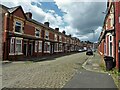
Welford Street
Terraced housing with cobbled road, the stereotype for Salford
Image: © Kevin Waterhouse
Taken: 4 Jul 2023
0.09 miles
10
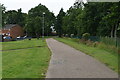
Footbridge over the Irwell
The Irwell Sculpture Trail uses this bridge. A former suspension bridge on this site collapsed on 12 April 1831, caused by soldiers marching in step across it.
Image: © Bill Boaden
Taken: 21 Jan 2012
0.10 miles