IMAGES TAKEN NEAR TO
Seaford Road, SALFORD, M6 6DD
Introduction
This page details the photographs taken nearby to Seaford Road, M6 6DD by members of the Geograph project.
The Geograph project started in 2005 with the aim of publishing, organising and preserving representative images for every square kilometre of Great Britain, Ireland and the Isle of Man.

There are currently over 7.5m images from over14,400 individuals and you can help contribute to the project by visiting https://www.geograph.org.uk
Image Map
Images are licensed for reuse under creativecommons.org/licenses/by-sa/2.0
Notes
- Clicking on the map will re-center to the selected point.
- The higher the marker number, the further away the image location is from the centre of the postcode.
Image Listing (60 Images Found)
Images are licensed for reuse under creativecommons.org/licenses/by-sa/2.0
Image
Details
Distance
5
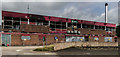
The Pavilion
The Pavilion, part of Salford University's Student Village.
Image: © Peter McDermott
Taken: 28 Aug 2016
0.12 miles
7
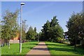
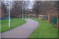
Irwell Riverside Walk
The walk and the Image run together here.
Image: © Glyn Baker
Taken: 31 Aug 2018
0.13 miles
10
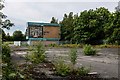
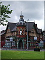
Cromwell Secondary School
The derelict remains of Cromwell Secondary School including the 'Tree of Knowledge' mural.
Image: © Peter McDermott
Taken: 23 Jun 2019
0.13 miles