IMAGES TAKEN NEAR TO
Welford Street, SALFORD, M6 6BB
Introduction
This page details the photographs taken nearby to Welford Street, M6 6BB by members of the Geograph project.
The Geograph project started in 2005 with the aim of publishing, organising and preserving representative images for every square kilometre of Great Britain, Ireland and the Isle of Man.

There are currently over 7.5m images from over14,400 individuals and you can help contribute to the project by visiting https://www.geograph.org.uk
Image Map (Loading...)


Getting Data...Please wait
Leaflet Map data © OpenStreetMap
Images are licensed for reuse under creativecommons.org/licenses/by-sa/2.0
Notes
- Clicking on the map will re-center to the selected point.
- The higher the marker number, the further away the image location is from the centre of the postcode.
Image Listing (53 Images Found)
Images are licensed for reuse under creativecommons.org/licenses/by-sa/2.0
Image
Details
Distance
1
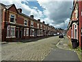
Welford Street
Terraced housing with cobbled road, the stereotype for Salford
Image: © Kevin Waterhouse
Taken: 4 Jul 2023
0.01 miles
2
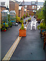
Secret gardens of Welford Street (East)
The regeneration of Charlestown resulted in Welford Street's alley gates, and a communal patio and potted garden appearing in the back alley.
Image: © Salford Sal
Taken: 28 Jul 2009
0.02 miles
3
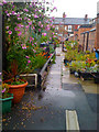
Secret gardens of Welford Street (west)
The secret gardens in the back alleys of Welford Street have existed for many years, but were limited to permanent structures, difficult to steal or vandalise. The regeneration of Charlestown resulted in Welford Street's alley gates, which allowed an existing gardening community to flourish, particularly to the west end of the street.
Image: © Salford Sal
Taken: 28 Jul 2009
0.02 miles
4
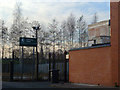
Irwell Valley, Salford
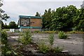
The location of the former Irwell Valley campus of the University of Salford, on Blandford Road, Salford, in Greater Manchester, England.
The building that was once here dated back to 1962, when it opened up as the Cromwell Secondary School for Girls. I understand it was later rebranded as the Irwell Valley High School. It must have changed hands around the turn of the millennium, as the University of Salford housed its art and design programme here between 2001 and 2007/2008. The building was identified for closure by the university, and in 2009 demolition began.
In this photo the university's welcome sign still remains, but the building is gone.
Image: © Steven Haslington
Taken: 26 Nov 2010
0.08 miles
5
Cromwell Secondary School
The derelict remains of Cromwell Secondary School including the 'Tree of Knowledge' mural.
Image: © Peter McDermott
Taken: 23 Jun 2019
0.08 miles
6
Salford's Tree Of Knowledge
A Ceramic and Tiled Mural designed by Alan Boyson and adorned the gable end of Cromwell Secondary School.
It has just be Grade II listed by English Heritage.
Image: © Edward Smith
Taken: 7 May 2007
0.10 miles
8
Broughton Road and Frederick Road Junction
Broughton Road and Frederick Road Junction where the Gatehouse is to David Lewis Playing Fields.
Image: © Edward Smith
Taken: 15 Jul 2008
0.14 miles
9
Gerald Road
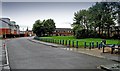
Gerald Road and the Albion Green on Albion Estate where the Albion Dog Track once stood.
Image: © Edward Smith
Taken: 9 Jun 2009
0.15 miles
10
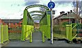
Gerald Road Footbridge
Gerald Road Footbridge crosses the River Irwell and connects Pendleton to Lower Broughton
Image: © Edward Smith
Taken: 10 Jan 2007
0.15 miles