1
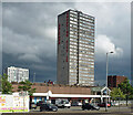
Shopping centre, Rossall Way, Salford
Elevated roadways and pedestrian subways lead to Salford Shopping City in Pendleton, the whole shebang dating from the late 1960s.
Image: © Stephen Richards
Taken: 29 May 2017
0.02 miles
2
Path to underpass near Pendleton Police Station
The underpass runs parallel to Broad Street (A6).
Image: © Bradley Michael
Taken: 10 Nov 2015
0.05 miles
3
Bus station in Pendleton
On Rossall Way.
Image: © philandju
Taken: 5 Jul 2017
0.06 miles
4
Footbridge over the A6 underpass
This crosses the middle of the A576 roundabout. St Thomas's Church is behind.
Image: © Bill Boaden
Taken: 11 Sep 2010
0.07 miles
5
The A6 underpass in Pendleton
This runs below the A576 roundabout which also has access to Salford Shopping City. Whilst very useful for traffic going to and from Manchester, an underpass like this cuts a swath through the local community.
Image: © Bill Boaden
Taken: 11 Sep 2010
0.07 miles
6
Double Postbox (M6 176)
At Rossall Way, Salford Shopping City, Pendleton.
Image: © Gerald England
Taken: 4 Jul 2017
0.08 miles
7
Briar Hill Court, Briar Hill Way, Salford
Atop Salford Shopping City is a 23-storey point block containing 136 dwellings. It was built in 1968-70.
Image: © Stephen Richards
Taken: 30 May 2017
0.08 miles
8
Bingo at Pendleton
The Gala bingo hall on Hankinson Way opposite Salford Shopping City.
Image: © Gerald England
Taken: 28 Apr 2010
0.09 miles
9
Tower blocks, Meyrick Road, Salford
John Lester and Eddie Colman Courts, two fifteen-storey slab blocks built in the early 1960s, each containing 112 dwellings (a third has been demolished).
Now student accommodation for Salford University.
Image: © Stephen Richards
Taken: 29 May 2017
0.09 miles
10
St James's House, Pendleton Way, Salford
A large office block near Salford Shopping City.
Image: © Stephen Richards
Taken: 29 May 2017
0.10 miles


