IMAGES TAKEN NEAR TO
Lilac Court, SALFORD, M6 5UL
Introduction
This page details the photographs taken nearby to Lilac Court, M6 5UL by members of the Geograph project.
The Geograph project started in 2005 with the aim of publishing, organising and preserving representative images for every square kilometre of Great Britain, Ireland and the Isle of Man.

There are currently over 7.5m images from over14,400 individuals and you can help contribute to the project by visiting https://www.geograph.org.uk
Image Map
Images are licensed for reuse under creativecommons.org/licenses/by-sa/2.0
Notes
- Clicking on the map will re-center to the selected point.
- The higher the marker number, the further away the image location is from the centre of the postcode.
Image Listing (52 Images Found)
Images are licensed for reuse under creativecommons.org/licenses/by-sa/2.0
Image
Details
Distance
2
Windsor Christian Centre
I'm surprised there are no signs outside this church. This is the base of the Manchester City Mission.
Image: © Bill Boaden
Taken: 11 Sep 2010
0.06 miles
3
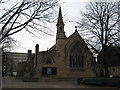
St Paul?s Church with Christ, Broadwalk, Salford
The Parish church of St Paul the Apostle, Pendlebury, with its attached rooms, house and garden, serves the parish of St Paul with Christ Church, which stretches from Oldfield Road to Salford’s Shopping City. The church was built in 1856 and consecrated in that year by the first Bishop of
Manchester. It was designed by Edwin Hugh Shellard in the Gothic style, The church, the parish rooms, the garden wall and gates were listed in 2003.http://www.achurchnearyou.com/stpauls-salford/
Image: © Richard Rogerson
Taken: 1 Feb 2010
0.09 miles
4
The Winston on Churchill Way
Appropriately named Holts pub.
Image: © Bill Boaden
Taken: 11 Sep 2010
0.09 miles
5
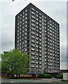
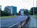
Cherry Tree Court, Kiwi Street, Salford
One of five seventeen-storey blocks in Pendleton, each containing 96 dwellings, built in the mid 1960s and fairly unusual in having architectural involvement, in this case Edinburgh University's Architecture Research Unit.
It has since been demolished.
Image: © Stephen Richards
Taken: 29 May 2017
0.09 miles
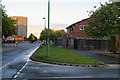
6

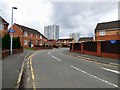
Churchill Way, Salford
Oncoming traffic is approaching a roundabout close to Salford Shopping Centre.
Image: © Bradley Michael
Taken: 14 Oct 2015
0.13 miles
8

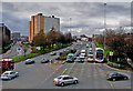
Churchill Way, Salford looking towards the Manchester Hilton
Image: © Richard Rogerson
Taken: 1 Feb 2010
0.15 miles
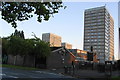
9
Broad Street
Broad Street viewed from the footbridge at the junction of Frederick Road.
Image: © Edward Smith
Taken: 5 Mar 2009
0.16 miles
10
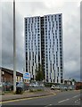
Spruce Court
Spruce Court was completed in 1969 with 23 storeys, 66m tall and housing 178 flats.
See how it looked in 2009 Image
The tower along with neighbouring Thorn Court Image underwent extensive renovations a few years ago http://www.mcconstruction.co.uk/projects/social-housing/thorn-court.html Following the tragedy at Grenfell Tower in London the cladding on the tower was tested and failed initial fire tests. Work has now begun on removing the cladding. http://www.manchestereveningnews.co.uk/news/greater-manchester-news/salford-tower-blocks-cladding-removed-13237054
Image: © Gerald England
Taken: 4 Jul 2017
0.16 miles