IMAGES TAKEN NEAR TO
Belvedere Road, SALFORD, M6 5HE
Introduction
This page details the photographs taken nearby to Belvedere Road, M6 5HE by members of the Geograph project.
The Geograph project started in 2005 with the aim of publishing, organising and preserving representative images for every square kilometre of Great Britain, Ireland and the Isle of Man.

There are currently over 7.5m images from over14,400 individuals and you can help contribute to the project by visiting https://www.geograph.org.uk
Image Map
Images are licensed for reuse under creativecommons.org/licenses/by-sa/2.0
Notes
- Clicking on the map will re-center to the selected point.
- The higher the marker number, the further away the image location is from the centre of the postcode.
Image Listing (74 Images Found)
Images are licensed for reuse under creativecommons.org/licenses/by-sa/2.0
Image
Details
Distance
1
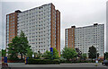
Tower blocks, Meyrick Road, Salford
John Lester and Eddie Colman Courts, two fifteen-storey slab blocks built in the early 1960s, each containing 112 dwellings (a third has been demolished).
Now student accommodation for Salford University.
Image: © Stephen Richards
Taken: 29 May 2017
0.03 miles
2
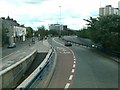
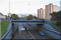
The underpass on Broad Street in Salford
View from sliproad off roundabout over the underpass
Image: © Raymond Knapman
Taken: 24 Jun 2011
0.04 miles
4
Woolpack Inn
The Woolpack Inn on Belvedere Road in Pendleton.
Image: © Peter McDermott
Taken: 22 Nov 2014
0.06 miles
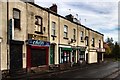
5
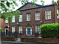
34 Broad Street, Salford
The largest house in a short row of late Georgian survivals. Decorative fanlight (Image]). Grade II listed.
Image: © Stephen Richards
Taken: 29 May 2017
0.08 miles
6
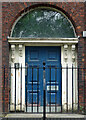
Detail of 34 Broad Street, Salford
Fancy fanlight and doorcase to this house: Image
Image: © Stephen Richards
Taken: 29 May 2017
0.08 miles
7
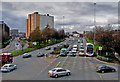
The A6 underpass in Pendleton
This runs below the A576 roundabout which also has access to Salford Shopping City. Whilst very useful for traffic going to and from Manchester, an underpass like this cuts a swath through the local community.
Image: © Bill Boaden
Taken: 11 Sep 2010
0.09 miles
8
Broad Street
Broad Street viewed from the footbridge at the junction of Frederick Road.
Image: © Edward Smith
Taken: 5 Mar 2009
0.09 miles
9
Broad Street
Buildings on Broad Street in Pendleton, Salford.
Image: © Peter McDermott
Taken: 12 Nov 2016
0.10 miles
10
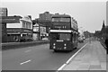
Broad Street, Salford ? 1971
A former Salford Corporation bus makes its way along a decaying Broad Street towards Manchester. The presence of a Montague Burton tailoring store – one of the few business still operating, shows that this was previously an flourishing retail and commercial street.
In the 21st century there is no sign whatsoever of commercial activity https://www.geograph.org.uk/photo/5349 . Only the tower block behind the bus and some of the buildings at the far end of the picture confirm that this is the same location.
The bus, now SELNEC 3165, was formerly Salford Corporation 319, a Leyland Atlantean with Park Royal body new in 1969, and was still running in the old Salford dark green livery.
This is one of a series of views featuring buses in the 60s, 70s, and 80s. https://www.geograph.org.uk/search.php?i=2114547&displayclass=slide
Image: © Alan Murray-Rust
Taken: 1 May 1971
0.13 miles