IMAGES TAKEN NEAR TO
St. Lukes Road, SALFORD, M6 5DH
Introduction
This page details the photographs taken nearby to St. Lukes Road, M6 5DH by members of the Geograph project.
The Geograph project started in 2005 with the aim of publishing, organising and preserving representative images for every square kilometre of Great Britain, Ireland and the Isle of Man.

There are currently over 7.5m images from over14,400 individuals and you can help contribute to the project by visiting https://www.geograph.org.uk
Image Map
Images are licensed for reuse under creativecommons.org/licenses/by-sa/2.0
Notes
- Clicking on the map will re-center to the selected point.
- The higher the marker number, the further away the image location is from the centre of the postcode.
Image Listing (76 Images Found)
Images are licensed for reuse under creativecommons.org/licenses/by-sa/2.0
Image
Details
Distance
1
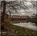
Reservoir
Reservoir in Seedley, Salford.
Image: © Peter McDermott
Taken: 7 Feb 2015
0.05 miles
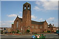
2
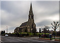
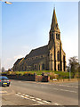
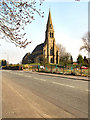
St Lukes
St Lukes Church in Seedley, Salford.
Image: © Peter McDermott
Taken: 7 Feb 2015
0.07 miles
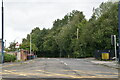
6
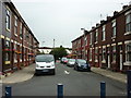
Thornfield Street, a street of hanging baskets
Image: © Ian S
Taken: 3 Sep 2011
0.10 miles
7
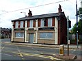
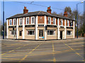
The Grey Mare
No longer giving the promised warm welcome
Image: © Graham Hogg
Taken: 24 Jun 2013
0.13 miles