IMAGES TAKEN NEAR TO
Asgard Drive, SALFORD, M5 4TQ
Introduction
This page details the photographs taken nearby to Asgard Drive, M5 4TQ by members of the Geograph project.
The Geograph project started in 2005 with the aim of publishing, organising and preserving representative images for every square kilometre of Great Britain, Ireland and the Isle of Man.

There are currently over 7.5m images from over14,400 individuals and you can help contribute to the project by visiting https://www.geograph.org.uk
Image Map
Images are licensed for reuse under creativecommons.org/licenses/by-sa/2.0
Notes
- Clicking on the map will re-center to the selected point.
- The higher the marker number, the further away the image location is from the centre of the postcode.
Image Listing (90 Images Found)
Images are licensed for reuse under creativecommons.org/licenses/by-sa/2.0
Image
Details
Distance
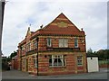
3
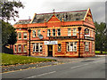
Bricklayers Arms
Ordsall Lane, Salford.
Image: © David Dixon
Taken: 17 Oct 2010
0.09 miles
4

Detail of Bricklayers Arms, Ordsall Lane, Salford
Terracotta detail to this pub Image] including the date 1906.
Image: © Stephen Richards
Taken: 29 May 2017
0.09 miles
5
The Bricklayer's Arms
Situated at the junction of Ordsall Lane and Woden Street, Salford. This pub now occupies a comparatively lonely position compared to the days when it was surrounded by high density terraced housing, factories and warehouses. SJ823975
Image: © Keith Williamson
Taken: 1 Sep 2005
0.10 miles
6
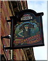
Bricklayers Arms sign, 146 Ordsall Lane, Salford
The name of the pub reflects the fact that from Victorian times until fairly recently it would have attracted its clientele from the nearby terraced houses and industries. All of these are now gone and replaced by new developments. Many of the new residents in the area are young, and probably prefer to take the tram to the hotspots of nearby Manchester city centre, than drink in the surviving Victorian pubs in Salford.
Image
Image: © P L Chadwick
Taken: 2 May 2010
0.11 miles
7
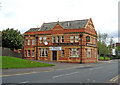
Bricklayers Arms, 146 Ordsall Lane, Salford
The pub survives, although nearly all of the contemporary buildings in this area have been demolished. These have been replaced in recent years by new developments. The pub has one end facing onto Ordsall Lane, and its main door faces a grassed area. Probably that is the site of the road it was originally fronting.
The pub is owned by the Joseph Holt brewery in Manchester, which was established in 1849, and is still family run. The pub is open but a banner announces that a new tenant is being sought. This is a familiar sight at present. It cannot be easy to run a pub in areas like this.
Image
Image: © P L Chadwick
Taken: 2 May 2010
0.11 miles
8
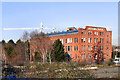
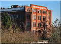
Gresham and Craven Factory
The Gresham and Craven site (former iron works?) on Ordsall Lane, Salford, viewed from the Woden Street footbridge.
Image: © David Dixon
Taken: 1 Feb 2012
0.12 miles
9
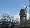
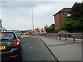
Working on a tower block
It seems to be Manchester's signature lately -tall cranes
Image: © Ian Greig
Taken: 25 Nov 2016
0.12 miles