IMAGES TAKEN NEAR TO
Derwent Street, SALFORD, M5 4SY
Introduction
This page details the photographs taken nearby to Derwent Street, M5 4SY by members of the Geograph project.
The Geograph project started in 2005 with the aim of publishing, organising and preserving representative images for every square kilometre of Great Britain, Ireland and the Isle of Man.

There are currently over 7.5m images from over14,400 individuals and you can help contribute to the project by visiting https://www.geograph.org.uk
Image Map
Images are licensed for reuse under creativecommons.org/licenses/by-sa/2.0
Notes
- Clicking on the map will re-center to the selected point.
- The higher the marker number, the further away the image location is from the centre of the postcode.
Image Listing (193 Images Found)
Images are licensed for reuse under creativecommons.org/licenses/by-sa/2.0
Image
Details
Distance
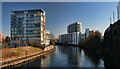
1
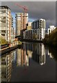
River Irwell
Flats alongside the Bridgewater Canal.
Image: © Peter McDermott
Taken: 27 Nov 2016
0.03 miles
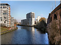
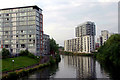
2
Confluence
Looking across the River Irwell from the Salford side of the Salford/Manchester boundary. The water of the River Medlock joins the Irwell here after meandering across and under parts of Manchester City centre. Also visible (under the railway arch) are Hulme locks which connected the nearby Bridgewater Canal with the River Irwell.
Image: © Keith Williamson
Taken: 21 Nov 2008
0.03 miles
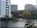
3
Hulme Lock, Bridgewater Canal, Manchester
This lock dropped boats from the Bridgewater Canal to the River Irwell (and to the Manchester Ship Canal). The River Medlock enters the Irwell next to the bottom gates. The railway viaducts above carry the line from Liverpool to Manchester Oxford Road, and the Metrolink trams. This lock is now disused, a new lock at Pomona connecting the Bridgewater with Salford Quays.
Image: © S Parish
Taken: Unknown
0.03 miles
5
River Irwell, Castlefield
Looking upstream, from the Woden Street footbridge. The apartment blocks directly ahead are at the confluence of the Irwell and Medlock rivers. The former Hulme Locks Junction Canal is through the arches of the railway viaduct on the right.
The Hulme Locks Junction Canal was only 200 metres in length, but it formed an important connection between the Bridgewater Canal and the River Irwell/Manchester Ship Canal but has fallen into a state of decline today having been replaced by a new lock which was built in 1995 near to Pamona Dock Number 3.
Image: © David Dixon
Taken: 1 Feb 2012
0.04 miles
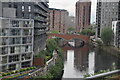
6
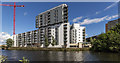
Water Street Apartments
Flats alongside the River Irwell in Salford.
Image: © Peter McDermott
Taken: 28 Aug 2015
0.04 miles
7
City living
New apartments along the Manchester Ship Canal
Image: © Anthony O'Neil
Taken: 21 Feb 2018
0.04 miles
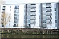
8
Water Street apartments
A modernist apartment block on the bank of the River Irwell close to the junction of the River Medlock.
Image: © Jonathan Wilkins
Taken: 27 Jun 2010
0.04 miles
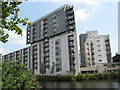
9
Vie Building
Looking along the Manchester Ship Canal to the Vie Building, a new development of flats.
Image: © Peter McDermott
Taken: 6 Apr 2013
0.04 miles
10
Living beside the water
Flats & apartments beside the Irwell.
Image: © Row17
Taken: 30 Jun 2009
0.05 miles