1
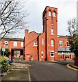
Fire Station Close
Behind the former fire station building is a square of houses built originally to accommodate firemen and their families. The square is lined on three sides by two and three-storey terraced houses.
For more information on the former Salford Central Fire Station see http://manchesterhistory.net/manchester/outside/SALFORD/firestation.html
Image: © Gerald England
Taken: 5 Mar 2018
0.02 miles
2
Central Fire Station, Salford – 4
Former firemen's housing at the back of the former fire station, now private residences. The right hand range is early 20th century, probably contemporary with the 1902 fire station, the far range built some time after WW1. Now named Firemen's Square.
Image: © Alan Murray-Rust
Taken: 23 Aug 2024
0.02 miles
3
Salford Central Fire Station
For more information on the former Salford Central Fire Station see http://manchesterhistory.net/manchester/outside/SALFORD/firestation.html
Image: © Gerald England
Taken: 5 Mar 2018
0.04 miles
4
Salford Central Fire Station
For more information on the former Salford Central Fire Station see http://manchesterhistory.net/manchester/outside/SALFORD/firestation.html
Image: © Gerald England
Taken: 5 Mar 2018
0.04 miles
5
Fire Station Close
From the end of Christchurch Avenue.
For more information on the former Salford Central Fire Station see http://manchesterhistory.net/manchester/outside/SALFORD/firestation.html
Image: © Gerald England
Taken: 5 Mar 2018
0.04 miles
6
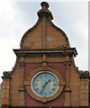
Central Fire Station, Salford – 2
Central gable with datestone and clock. See
Image for location
Image: © Alan Murray-Rust
Taken: 23 Aug 2024
0.04 miles
7
Salford Central Fire Station,Albert Bentley Place
Originally called Albion Place, it was renamed Albert Bentley Place in 2015 https://www.bbc.co.uk/news/uk-england-manchester-31663040 after the man who became head of the local fire brigade in 1898.
For more information on the former Salford Central Fire Station see http://manchesterhistory.net/manchester/outside/SALFORD/firestation.html
Image: © Gerald England
Taken: 5 Mar 2018
0.04 miles
8
Salford Fire Station Clock
On the former Salford Central Fire Station
Image
Image: © Gerald England
Taken: 5 Mar 2018
0.04 miles
9
Central Fire Station, Salford – 1
The original municipal fire station of 1902 in brick and decorative terracotta, now part of the University of Salford.
Image: © Alan Murray-Rust
Taken: 23 Aug 2024
0.04 miles
10
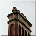
Central Fire Station, Salford – 3
Chimney stack with decorative terracotta stack and distinctive pots. See
Image for location
Image: © Alan Murray-Rust
Taken: 23 Aug 2024
0.04 miles


