IMAGES TAKEN NEAR TO
Markendale Place, SALFORD, M5 3GW
Introduction
This page details the photographs taken nearby to Markendale Place, M5 3GW by members of the Geograph project.
The Geograph project started in 2005 with the aim of publishing, organising and preserving representative images for every square kilometre of Great Britain, Ireland and the Isle of Man.

There are currently over 7.5m images from over14,400 individuals and you can help contribute to the project by visiting https://www.geograph.org.uk
Image Map (Loading...)


Getting Data...Please wait
Leaflet Map data © OpenStreetMap
Images are licensed for reuse under creativecommons.org/licenses/by-sa/2.0
Notes
- Clicking on the map will re-center to the selected point.
- The higher the marker number, the further away the image location is from the centre of the postcode.
Image Listing (106 Images Found)
Images are licensed for reuse under creativecommons.org/licenses/by-sa/2.0
Image
Details
Distance

4
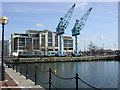
Ontario Basin, Salford Quays
Dock cranes at Ontario Basin, Salford Quays, with a Metrolink tram passing on its way to Eccles.
Image: © Martin Clark
Taken: Unknown
0.06 miles

9
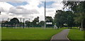
All Weather Sports Pitches in Ordsall Park
Image: © Paul Collins
Taken: 6 Aug 2019
0.09 miles
