IMAGES TAKEN NEAR TO
Red Rose Retail Centre, Regent Road, SALFORD, M5 3GR
Introduction
This page details the photographs taken nearby to Red Rose Retail Centre, Regent Road, M5 3GR by members of the Geograph project.
The Geograph project started in 2005 with the aim of publishing, organising and preserving representative images for every square kilometre of Great Britain, Ireland and the Isle of Man.

There are currently over 7.5m images from over14,400 individuals and you can help contribute to the project by visiting https://www.geograph.org.uk
Image Map (Loading...)


Getting Data...Please wait
Leaflet Map data © OpenStreetMap
Images are licensed for reuse under creativecommons.org/licenses/by-sa/2.0
Notes
- Clicking on the map will re-center to the selected point.
- The higher the marker number, the further away the image location is from the centre of the postcode.
Image Listing (38 Images Found)
Images are licensed for reuse under creativecommons.org/licenses/by-sa/2.0
Image
Details
Distance
1
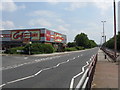
Carpetright, Salford
One of several large retail establishments along Regent Road (A57) in Salford. The road is momentarily quiet as traffic is queued back at the M602 roundabout.
Image: © Peter Whatley
Taken: 1 Jul 2009
0.02 miles
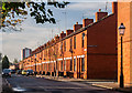
2
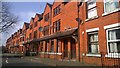
Coronation Street, Salford
Coronation Street in Salford, is a beautiful urban street composed of red-brick terraced housing.
Image: © Steven Haslington
Taken: 30 Mar 2014
0.07 miles
3

Ordsall Lane No.4 Signalbox and sidings
Most of the signalbox's levers were redundant by 1977, but the large box survived for a few more years.
Image: © Peter Whatley
Taken: Unknown
0.08 miles
4
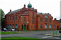
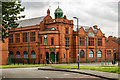
Club, St Ignatius Way, Salford
Salford Lads' Club, by Henry Lord, 1904. It has a very well preserved interior. The listing states that it was "designed to provide sporting, recreational and performance facilities, and is thought to be the most complete example of this rare form of social provision to survive in England". Paid for by J.G. and W.G. Groves for the residents of the city's first municipal housing estate. Grade II listed.
Still a youth club, probably best known for featuring on an album cover of the Smiths.
Image: © Stephen Richards
Taken: 29 May 2017
0.09 miles
5
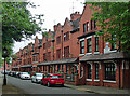
2-38 Regent Square, Salford
The square is the focal point of the New Barracks Estate, Salford's first foray into municipal housing. Built, on the site of an infantry barracks, by Henry Lord who won a competition in 1899. The housing is pleasantly varied, though most of the original thirty-two shops have gone.
Image: © Stephen Richards
Taken: 29 May 2017
0.09 miles
6
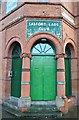
There is a light that never goes out!
The light above the fanlight of possibly one of the more famous doorways in British contemporary music is not switched on today, though.
Image: © Bobby Clegg
Taken: 17 Jan 2015
0.09 miles
7
Salford Lads Club
Salford Lads Club in Ordsall.
Image: © Peter McDermott
Taken: 14 Jun 2017
0.09 miles
8
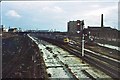
Ordsall Lane railway lands 1977
The view east from Ordsall Lane no.4 signalbox shows a Newcastle-Liverpool train passing amidst a sea of disused railway facilities. Sidings on the left served a gasworks, disused by 1977 while those on the right were for reforming trains. The locomotive is about to pass over the junction between the line from Salford and the link toward Deansgate which physically diverged at Ordsall Lane no.2 signalbox. In the foreground are the remains of the former slow lines between Barton Moss Junction and Manchester Exchange station.
Image: © Peter Whatley
Taken: Unknown
0.12 miles
10
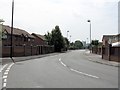
Ordsall
Gloucester Street in Ordsall.
Image: © Peter McDermott
Taken: 11 Oct 2014
0.12 miles