IMAGES TAKEN NEAR TO
Exchange Quay, SALFORD, M5 3EJ
Introduction
This page details the photographs taken nearby to Exchange Quay, M5 3EJ by members of the Geograph project.
The Geograph project started in 2005 with the aim of publishing, organising and preserving representative images for every square kilometre of Great Britain, Ireland and the Isle of Man.

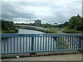
There are currently over 7.5m images from over14,400 individuals and you can help contribute to the project by visiting https://www.geograph.org.uk
Image Map
Images are licensed for reuse under creativecommons.org/licenses/by-sa/2.0
Notes
- Clicking on the map will re-center to the selected point.
- The higher the marker number, the further away the image location is from the centre of the postcode.
Image Listing (231 Images Found)
Images are licensed for reuse under creativecommons.org/licenses/by-sa/2.0
Image
Details
Distance
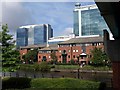
1
New Development
Alongside Manchester Ship Canal (includes former Manchester Liners HQ)
Image: © Anthony O'Neil
Taken: 21 Feb 2018
0.01 miles
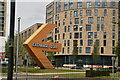
2
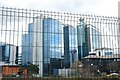
Exchange Quay
The new office complex seen across the ship canal from beneath the Metro viaduct at Pomona Strand.
Image: © Derek Harper
Taken: 19 Aug 2010
0.04 miles
3
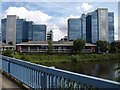
Exchange Quay
Viewed from the eastern of the Trafford Road Bridges over the Manchester Ship Canal. The high blocks date from the 1990s.
Image: © Derek Harper
Taken: 19 Aug 2010
0.05 miles
4
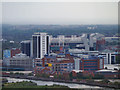
View towards Old Trafford
Looking towards Old Trafford (with the Manchester Ship Canal in the foreground) from the Beetham Tower (Hilton Hotel).
Click http://zoom.it/Qz2z for a wider image which may be zoomed and scrolled.
Image: © David Dixon
Taken: 24 Aug 2012
0.05 miles
5
Manchester Ship Canal
From Trafford Road Bridge. On the right is the new(ish) tramline to the Trafford Centre from Pomona. A sign of the times is a discarded face-mask by the side of the pavement,
Image: © Gerald England
Taken: 31 Jul 2021
0.06 miles
7
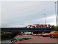
Two bridges over the Manchester Ship Canal
Trafford Road bridges, the nearest bears traffic going south while the other takes north-bound traffic.
Image: © Eirian Evans
Taken: 28 Jun 2014
0.07 miles
8
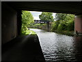
Old Trafford, turnover bridge
Throstle Nest Bridge, where the towpath changes from the North to South of the Bridgewater Canal. http://www.penninewaterways.co.uk/bridgewater/bri51.htm
Image: © Mike Faherty
Taken: 31 Aug 2009
0.07 miles
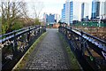
10
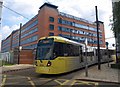
Metrolink tram, Salford
I was trying to find my way on to the towpath of the Manchester Ship Canal, and had wondered why the street ahead had a "no pedestrians" sign, when the answer suddenly appeared round the corner.
Image: © Derek Harper
Taken: 19 Aug 2010
0.08 miles