IMAGES TAKEN NEAR TO
Labrador Quay, SALFORD, M50 3YH
Introduction
This page details the photographs taken nearby to Labrador Quay, M50 3YH by members of the Geograph project.
The Geograph project started in 2005 with the aim of publishing, organising and preserving representative images for every square kilometre of Great Britain, Ireland and the Isle of Man.

There are currently over 7.5m images from over14,400 individuals and you can help contribute to the project by visiting https://www.geograph.org.uk
Image Map
Images are licensed for reuse under creativecommons.org/licenses/by-sa/2.0
Notes
- Clicking on the map will re-center to the selected point.
- The higher the marker number, the further away the image location is from the centre of the postcode.
Image Listing (323 Images Found)
Images are licensed for reuse under creativecommons.org/licenses/by-sa/2.0
Image
Details
Distance
1
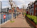
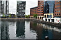
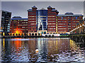
Erie Basin, Salford Quays
Formerly Dock 9 at Manchester Docks before the area was redeveloped as Salford Quays.
Image: © David Dixon
Taken: 5 May 2016
0.03 miles
4
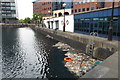
Floating detritus (mostly plastic) in the Eirie basin
Image: © Philip Jeffrey
Taken: 11 May 2018
0.05 miles
6
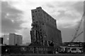
No. 2 Grain Elevator - I refuse to die
This large grain elevator at the end of Dock No. 9 at Salford was built in 1915 and was indeed seen to be leaning at this crazy angle during demolition. It is now a distant memory and this area is part of Salford Quays.
Image: © Chris Allen
Taken: 17 Sep 1983
0.05 miles
7
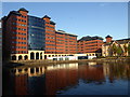
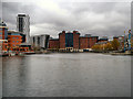
Office buildings at the head of Erie Basin
Part of the redevelopment of the old docks at Salford Quays.
Image: © Rod Allday
Taken: 15 Jul 2014
0.06 miles
9
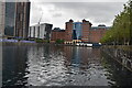
Erie Basin and The Anchorage Building, Salford Quays
Erie Basin is the eastern section of what used to be Dock 9 of the Manchester Docks before regeneration. This was the largest and newest dock, built on the site of the Manchester Racecourse and officially opened by King Edward VII and Queen Alexandra on 13 July 1905.
The large office block at the head of the dock standing at the head of Erie Basin is called The Anchorage. Completed in 1991, it was the first large office block to be constructed in the Quays, completed in 1991.
http://www.mangeogsoc.org.uk/egm/1_6_Salford_Quays.pdf Salford Quays Fieldwork Guide by CM Law (formerly of Salford University), 1998 revised 2012 by Paul Hindle, Manchester Geographical Society
Image: © David Dixon
Taken: 17 Dec 2015
0.07 miles
10
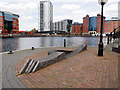
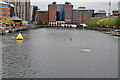
Irwell Sculpture Trail, Eries Rest
Sculpture made in 2010 with local families from Weaste and Ordsall and Salford based artist Beverley Gee and sited at the side of the Erie Basin at Salford Quays. The shape of this sculpture echoes the ebb and flow of the Canal (http://www.irwellsculpturetrail.co.uk/sculpture.html?name=Eries%20Rest Irwell Sculpture Trail).
Image: © David Dixon
Taken: 5 May 2016
0.07 miles