IMAGES TAKEN NEAR TO
Coronet Way, SALFORD, M50 1RE
Introduction
This page details the photographs taken nearby to Coronet Way, M50 1RE by members of the Geograph project.
The Geograph project started in 2005 with the aim of publishing, organising and preserving representative images for every square kilometre of Great Britain, Ireland and the Isle of Man.

There are currently over 7.5m images from over14,400 individuals and you can help contribute to the project by visiting https://www.geograph.org.uk
Image Map
Images are licensed for reuse under creativecommons.org/licenses/by-sa/2.0
Notes
- Clicking on the map will re-center to the selected point.
- The higher the marker number, the further away the image location is from the centre of the postcode.
Image Listing (76 Images Found)
Images are licensed for reuse under creativecommons.org/licenses/by-sa/2.0
Image
Details
Distance
5
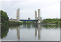
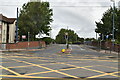
Centenary Bridge, Manchester Ship Canal
Centenary Bridge links Eccles with Trafford Park.
Image: © Martin Clark
Taken: Unknown
0.11 miles
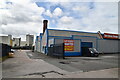
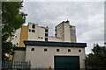
6
Salford, Coronet Mill
Operated by Allied Mills. http://www.allied-mills.co.uk/english/index.php
Image: © Mike Faherty
Taken: 18 Sep 2011
0.11 miles

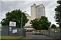
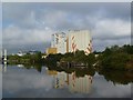
8
Manchester Ship Canal, Coronet Mill
Coronet Mill (part of the Allied Mills group) alongside the Manchester Ship Canal at Salford.
Image: © David Dixon
Taken: 13 Mar 2011
0.11 miles
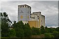
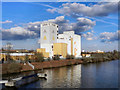
9

Coronet Flour Mill
On the north bank of the Manchester Ship Canal.
Image: © Christine Johnstone
Taken: 13 Apr 2013
0.12 miles