IMAGES TAKEN NEAR TO
Pacific Way, SALFORD, M50 1DL
Introduction
This page details the photographs taken nearby to Pacific Way, M50 1DL by members of the Geograph project.
The Geograph project started in 2005 with the aim of publishing, organising and preserving representative images for every square kilometre of Great Britain, Ireland and the Isle of Man.

There are currently over 7.5m images from over14,400 individuals and you can help contribute to the project by visiting https://www.geograph.org.uk
Image Map
Images are licensed for reuse under creativecommons.org/licenses/by-sa/2.0
Notes
- Clicking on the map will re-center to the selected point.
- The higher the marker number, the further away the image location is from the centre of the postcode.
Image Listing (41 Images Found)
Images are licensed for reuse under creativecommons.org/licenses/by-sa/2.0
Image
Details
Distance
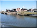
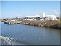
1
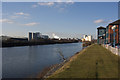
The Manchester Ship Canal near Weaste
With Canada Geese trimming the lawn
Image: © Ian Greig
Taken: 28 Jan 2011
0.03 miles
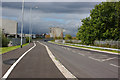
4

Old and new, downstream of Mode Wheel Locks
Disused landing stage serves no purpose for the new industrial premises.
Image: © Christine Johnstone
Taken: 13 Apr 2013
0.05 miles
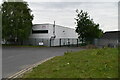
6
New workplaces at the west end of Broadway
No need any more of the landing stage.
Image: © Christine Johnstone
Taken: 13 Apr 2013
0.06 miles
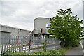
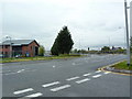
10
Depot and wharf, south of Coronet Way
Seen from a ship heading down the Manchester Ship Canal.
Image: © Christine Johnstone
Taken: 13 Apr 2013
0.08 miles