IMAGES TAKEN NEAR TO
Kingham Drive, MANCHESTER, M4 7JT
Introduction
This page details the photographs taken nearby to Kingham Drive, M4 7JT by members of the Geograph project.
The Geograph project started in 2005 with the aim of publishing, organising and preserving representative images for every square kilometre of Great Britain, Ireland and the Isle of Man.

There are currently over 7.5m images from over14,400 individuals and you can help contribute to the project by visiting https://www.geograph.org.uk
Image Map
Images are licensed for reuse under creativecommons.org/licenses/by-sa/2.0
Notes
- Clicking on the map will re-center to the selected point.
- The higher the marker number, the further away the image location is from the centre of the postcode.
Image Listing (320 Images Found)
Images are licensed for reuse under creativecommons.org/licenses/by-sa/2.0
Image
Details
Distance
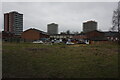
2
Woodward Street
The Woodward Street housing development.
Image: © Peter McDermott
Taken: 26 Jul 2020
0.05 miles
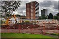
4

Woodward Street
The Woodward Street housing development.
For a similar view earlier in construction see: Image
Image: © Peter McDermott
Taken: 3 Aug 2021
0.05 miles
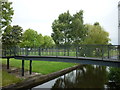
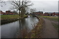
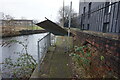
8
Rochdale Canal at Butler Street, Ancoats
Note the profusion of boarded up houses by the canal.
Image: © Peter Whatley
Taken: 28 Feb 2009
0.06 miles
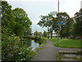
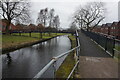
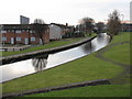
9
Rochdale Canal towards bridge #87A
At this point the towpath is / was blocked off to walkers.
Image: © Ian S
Taken: 2 Mar 2022
0.07 miles
10

Rochdale Canal towards bridge #87A
At this point the towpath is / was blocked off to walkers.
Image: © Ian S
Taken: 2 Mar 2022
0.07 miles