IMAGES TAKEN NEAR TO
Pollard Street, MANCHESTER, M4 7JB
Introduction
This page details the photographs taken nearby to Pollard Street, M4 7JB by members of the Geograph project.
The Geograph project started in 2005 with the aim of publishing, organising and preserving representative images for every square kilometre of Great Britain, Ireland and the Isle of Man.

There are currently over 7.5m images from over14,400 individuals and you can help contribute to the project by visiting https://www.geograph.org.uk
Image Map
Images are licensed for reuse under creativecommons.org/licenses/by-sa/2.0
Notes
- Clicking on the map will re-center to the selected point.
- The higher the marker number, the further away the image location is from the centre of the postcode.
Image Listing (318 Images Found)
Images are licensed for reuse under creativecommons.org/licenses/by-sa/2.0
Image
Details
Distance
1
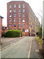
Hope Mill
Former mill on Pollard Street, now split into industrial units.
Image: © David Dixon
Taken: 19 May 2010
0.01 miles
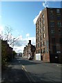
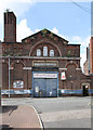
2
Hope Works, Pollard Street
This apparently unprepossessing building is more interesting than it appears. It was built in 1824 as a textile mill and represents an early example of a mill built to be operated by steam power. It is considered to be sufficiently original to justify Grade II* listing. The listing description contains the following comments: " . . . one of the best-preserved examples of its type in Manchester, one which retains extensive evidence for the evolution of successive power systems, and which includes an innovative prefabricated iron roofing system."
Image: © Alan Murray-Rust
Taken: 7 Aug 2013
0.01 miles
4
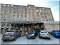
Hope Mill, Manchester
Hope Mill Manchester, showing the entrance to the theatre.
Image: © Paul Foster
Taken: 9 Sep 2023
0.02 miles
5
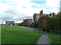
Pollard Street
Typical Ancoats industrial street. Beyond the former Ancoats Works (originally an engineering works) is the seven-storey Hope Mills http://www.geograph.org.uk/photo/3593256 .
Image: © Alan Murray-Rust
Taken: 7 Aug 2013
0.02 miles
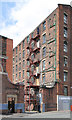
6
Rear view of mills between Pollard Street and Ashton Canal
Image: © Alexander P Kapp
Taken: 25 Oct 2011
0.03 miles
7
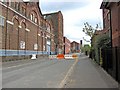
Ancoats Works
Former engineering works (later cabinet making) on Pollard Street.
Image: © Alan Murray-Rust
Taken: 7 Aug 2013
0.03 miles
8
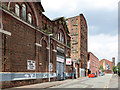
Industrial buildings in Pollard Street
A lot of old industrial buildings survive in Pollard Street. The building on the left, nearest the camera, is Ancoats Works, according to the name above the entrance. The barrier across the road relates to a temporary closure to traffic of the section in the foreground, due to construction of a Manchester Metrolink extension.
Image
Image: © P L Chadwick
Taken: 2 May 2010
0.03 miles
9

Doorway to Ancoats Works
Door Leading to Old Ancoats Works
Image: © Paul Foster
Taken: 9 Sep 2023
0.03 miles
10
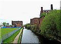
Ashton Canal
The canal here is flanked by some old industrial buildings - a typical urban canalscape. In the distance is Beswick Street Bridge.
Image: © P L Chadwick
Taken: 2 May 2010
0.03 miles