IMAGES TAKEN NEAR TO
Mayes Gardens, MANCHESTER, M4 7FN
Introduction
This page details the photographs taken nearby to Mayes Gardens, M4 7FN by members of the Geograph project.
The Geograph project started in 2005 with the aim of publishing, organising and preserving representative images for every square kilometre of Great Britain, Ireland and the Isle of Man.

There are currently over 7.5m images from over14,400 individuals and you can help contribute to the project by visiting https://www.geograph.org.uk
Image Map
Images are licensed for reuse under creativecommons.org/licenses/by-sa/2.0
Notes
- Clicking on the map will re-center to the selected point.
- The higher the marker number, the further away the image location is from the centre of the postcode.
Image Listing (370 Images Found)
Images are licensed for reuse under creativecommons.org/licenses/by-sa/2.0
Image
Details
Distance
2
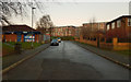
St. Anne's Roman Catholic Primary School (2), Carruthers Street
A modern voluntary aided small school, which is described as being near the centre of Manchester set in an area of very challenging social circumstances. The school has around 170 pupils. Photographed from Pollard Street.
Image
Image
Image: © P L Chadwick
Taken: 2 May 2010
0.05 miles
3

St. Anne's Roman Catholic Primary School (3), Carruthers Street
Image: © P L Chadwick
Taken: 2 May 2010
0.05 miles
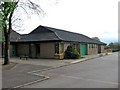
5
Every Street
From the top deck of a bus. All Souls church Image is now the Manchester Miracle Centre.
Image: © Gerald England
Taken: 1 Mar 2012
0.06 miles
6
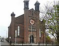
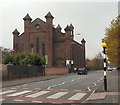
All Souls' Church
All Souls' Church on Every Street was designed by the architect William Hayley and completed in 1840. Pevsner describes it as "ideosyncratic Romanesque" in style. The church became redundant and closed in 1981. In subsequent years it had a number of uses including as a carpenter's workshop. More photos and plans at http://manchesterhistory.net/manchester/tours/tour12/area12page66.html
Recently it has been repaired and restored awaiting reopening as the Manchester Miracle Centre.
Image: © Gerald England
Taken: 1 Nov 2010
0.06 miles
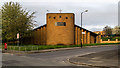
8
Apartments in Malta Street, Manchester
An attractive looking block of apartments, just off Pollard Street. Photographed from near the corner of Pollard Street and Munday Street.
Image: © P L Chadwick
Taken: 2 May 2010
0.07 miles
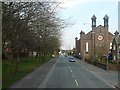
9
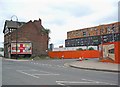
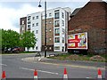
Junction of Pollard Street and Munday Street, Manchester
Munday Street is the one turning off on the right, and leads to the Milliners Wharf development. The new apartment block in the distance is called Chips. The old building on the left was in rather a bad state of repair, see:- Image
Image: © P L Chadwick
Taken: 2 May 2010
0.07 miles
10
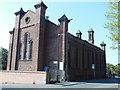
Manchester Miracle Centre
All Souls' Church sits on the corner of Every Street and Harding Street in Ancoats. The church was designed by the architect William Hayley and completed in 1840. Pevsner describes it as "ideosyncratic Romanesque" in style. The church became redundant and closed in 1981. In the years that followed it had a number of uses including as a carpenter's workshop. More photos and plans at http://manchesterhistory.net/manchester/tours/tour12/area12page66.html
It appears that in recent times All Souls has been repaired and restored awaiting reopening as the Manchester Miracle Centre.
Image: © Gerald England
Taken: 1 Nov 2010
0.07 miles