IMAGES TAKEN NEAR TO
Great Ancoats Street, MANCHESTER, M4 7FE
Introduction
This page details the photographs taken nearby to Great Ancoats Street, M4 7FE by members of the Geograph project.
The Geograph project started in 2005 with the aim of publishing, organising and preserving representative images for every square kilometre of Great Britain, Ireland and the Isle of Man.

There are currently over 7.5m images from over14,400 individuals and you can help contribute to the project by visiting https://www.geograph.org.uk
Image Map
Images are licensed for reuse under creativecommons.org/licenses/by-sa/2.0
Notes
- Clicking on the map will re-center to the selected point.
- The higher the marker number, the further away the image location is from the centre of the postcode.
Image Listing (307 Images Found)
Images are licensed for reuse under creativecommons.org/licenses/by-sa/2.0
Image
Details
Distance
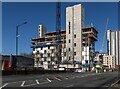
1
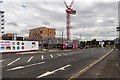
Housing Development
New flats under construction.
Image: © Peter McDermott
Taken: 29 Aug 2015
0.01 miles

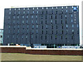
4
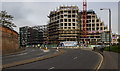
X1 Eastbank - The Plaza
Phase II of the X1 Eastbank development.
Image: © Peter McDermott
Taken: 16 Apr 2017
0.06 miles
5

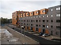
Isaac Way
Development of flats on Isaac Way in Ancoats.
Image: © Peter McDermott
Taken: 23 Aug 2014
0.07 miles
6
New Islington
Apartment block and shops on Great Ancoats Street between Pollard Street and Every Street.
Image: © Gerald England
Taken: 1 Mar 2012
0.07 miles
7
ibis budget Hotel
Off Great Ancoats Street, viewed from the Ashton Canal.
Image: © Thomas Nugent
Taken: 2 Apr 2013
0.08 miles
9

Ibis Hotel
The Ibis Hotel on Pollard Street in Ancoats, Manchester.
Image: © Peter McDermott
Taken: 6 Apr 2013
0.09 miles
10
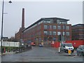
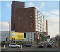
Ancoats Mills
Redevelopment of former cotton mills in Ancoats.
Image: © John M
Taken: 11 Oct 2011
0.09 miles