IMAGES TAKEN NEAR TO
Munday Street, MANCHESTER, M4 7BG
Introduction
This page details the photographs taken nearby to Munday Street, M4 7BG by members of the Geograph project.
The Geograph project started in 2005 with the aim of publishing, organising and preserving representative images for every square kilometre of Great Britain, Ireland and the Isle of Man.

There are currently over 7.5m images from over14,400 individuals and you can help contribute to the project by visiting https://www.geograph.org.uk
Image Map
Images are licensed for reuse under creativecommons.org/licenses/by-sa/2.0
Notes
- Clicking on the map will re-center to the selected point.
- The higher the marker number, the further away the image location is from the centre of the postcode.
Image Listing (441 Images Found)
Images are licensed for reuse under creativecommons.org/licenses/by-sa/2.0
Image
Details
Distance
1
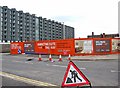
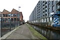
Milliners Wharf, Manchester
This is a huge development of apartments to rent, and for sale. They are probably absolutely delightful inside, but the forbidding grey exterior does rather remind me of some Communist era blocks I visited in Plzen in what is now the Czech Republic in 1990. It's strange, as there are some attractive developments around here, but this one is so big it dominates the scene. Photographed from Munday Street.
Image: © P L Chadwick
Taken: 2 May 2010
0.01 miles
2
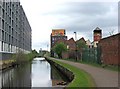
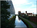
Ashton Canal southwest of Carruthers Street Bridge, Manchester
The canal opened in 1796, but like most others declined as railways were built. In the 1960's, part of it was in danger of being culverted, but fortunately the canal survived and re-opened to navigation in 1974. Today it forms part of the popular Cheshire Ring of canals.
Image
Image: © P L Chadwick
Taken: 2 May 2010
0.02 miles
3
Ashton Canal, Ancoats
Demolition was all around on this stretch approaching the Carr Street bridge
Image: © Keith Edkins
Taken: 28 Jun 2006
0.02 miles
4

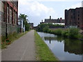
Ashton Canal, Ancoats
Close to the city centre, the canal here is surrounded by industrial premises.
Image: © David Dixon
Taken: 21 Nov 2012
0.02 miles
5
Ashton Canal
Looking south from Carruthers Street.
Image: © David Dixon
Taken: 19 May 2010
0.02 miles
6
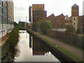
Ashton Canal
On the right is Milliners Wharf situated on the site of the former Hat Box factory. On the left is Stubbs Mill Image
Image: © Gerald England
Taken: 19 Feb 2024
0.02 miles
7
Ashton Canal from Carruthers Street, Manchester
Image: © Alexander P Kapp
Taken: 25 Oct 2011
0.02 miles
8
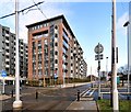
The Hatbox
Another new luxury 144 apartment block has now been completed at New Islington. The Hatbox's facilities include a sky garden complete with oversized chess board, table tennis and BBQ areas, bicycle storage and secure parking. It is named after the Hatbox factory which originally stood on the site.
Image: © Gerald England
Taken: 14 Jan 2017
0.03 miles
9
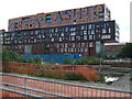
Chips - by Will Alsop
Architect Will Alsop's apartment block at New Islington, Manchester. 9 storeys high and it was said to look like three potato chips on top of each other. It's alongside the Ashton Canal, and the facings feature the names of local waterways.
Image: © S Parish
Taken: 15 Jun 2009
0.03 miles
10
Derelict Building, Ancoats
A derelict mill or factory next to the Ashton Canal at Ancoats.
Image: © David Dixon
Taken: 21 Nov 2012
0.03 miles