IMAGES TAKEN NEAR TO
Pollard Street, MANCHESTER, M4 7AS
Introduction
This page details the photographs taken nearby to Pollard Street, M4 7AS by members of the Geograph project.
The Geograph project started in 2005 with the aim of publishing, organising and preserving representative images for every square kilometre of Great Britain, Ireland and the Isle of Man.

There are currently over 7.5m images from over14,400 individuals and you can help contribute to the project by visiting https://www.geograph.org.uk
Image Map
Images are licensed for reuse under creativecommons.org/licenses/by-sa/2.0
Notes
- Clicking on the map will re-center to the selected point.
- The higher the marker number, the further away the image location is from the centre of the postcode.
Image Listing (319 Images Found)
Images are licensed for reuse under creativecommons.org/licenses/by-sa/2.0
Image
Details
Distance
1
Ancoats, Merrill Street
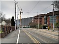
Looking along Merrill Street towards the city centre. Most of the area's old industrial buildings have been replaced by residential units, including the new apartment block being built ahead in Pollard Street.
Image: © David Dixon
Taken: 7 Feb 2015
0.01 miles
2
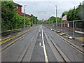
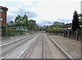
Tram tracks in Merrill Street, Manchester
The rails have now been laid in Merrill Street for the Manchester Metrolink extension to Droylsden, and Ashton-under-Lyne. The overhead power lines have also been installed, but the works are currently still fenced off. This photograph was taken through the fencing, at the junction of Merrill Street and Carruthers Street.
A year earlier (May 2010) the rails had still to be laid:- Image
Image: © L S Wilson
Taken: 7 May 2011
0.01 miles
3
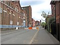
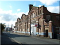
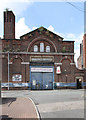
Industrial buildings in Pollard Street
A lot of old industrial buildings survive in Pollard Street. The building on the left, nearest the camera, is Ancoats Works, according to the name above the entrance. The barrier across the road relates to a temporary closure to traffic of the section in the foreground, due to construction of a Manchester Metrolink extension.
Image
Image: © P L Chadwick
Taken: 2 May 2010
0.01 miles
4
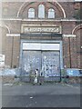
Doorway to Ancoats Works
Door Leading to Old Ancoats Works
Image: © Paul Foster
Taken: 9 Sep 2023
0.02 miles
5
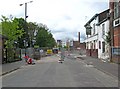
Merrill Street closed for Manchester Metrolink extension construction
Merrill Street, which is part of the A662 road, lies on the route of Metrolink's new tramway to Droylsden, which is due to open around Spring 2012. Funding has now been granted to extend it further from Droylsden to Ashton-under-Lyne, but that section will open later. The route passes through Merrill Street, where the trams will run in the street with other traffic. The other section where this will happen is along a length of Ashton New Road. When photographed in early May 2010, most of Merrill Street was closed to allow construction of the track. Preparatory work was being done, but the rails had not been laid in this section.
Image
Image: © P L Chadwick
Taken: 2 May 2010
0.02 miles
6
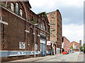
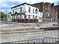
Pollard Street closed for Metrolink extension works
Ahead behind the barriers work was being undertaken relating to the extension of the Manchester Metrolink tramway system. On the right is the derelict Bank of England public house.
Image
Image
Image: © P L Chadwick
Taken: 2 May 2010
0.02 miles
7
Ancoats Works Pollard Street, Manchester
Image: © Alexander P Kapp
Taken: 25 Oct 2011
0.02 miles
8
Pollard Street
Typical Ancoats industrial street. Beyond the former Ancoats Works (originally an engineering works) is the seven-storey Hope Mills http://www.geograph.org.uk/photo/3593256 .
Image: © Alan Murray-Rust
Taken: 7 Aug 2013
0.02 miles
9
Ancoats Works
Former engineering works (later cabinet making) on Pollard Street.
Image: © Alan Murray-Rust
Taken: 7 Aug 2013
0.03 miles
10
Bank of England public house, 103 Pollard Street
This derelict pub was known as The Bank of England. A lot of new trendy looking apartment blocks have been built nearby, and this area is now sometimes known as New Islington. In front of the pub preparatory work was going on in respect of the laying of rails for an extension to the Manchester Metrolink. Next to the old pub are some Victorian looking industrial buildings, which have managed to survive so far.
Image
Image
Image: © P L Chadwick
Taken: 2 May 2010
0.03 miles