IMAGES TAKEN NEAR TO
Hugh Oldham Way, MANCHESTER, M4 6EY
Introduction
This page details the photographs taken nearby to Hugh Oldham Way, M4 6EY by members of the Geograph project.
The Geograph project started in 2005 with the aim of publishing, organising and preserving representative images for every square kilometre of Great Britain, Ireland and the Isle of Man.

There are currently over 7.5m images from over14,400 individuals and you can help contribute to the project by visiting https://www.geograph.org.uk
Image Map
Images are licensed for reuse under creativecommons.org/licenses/by-sa/2.0
Notes
- Clicking on the map will re-center to the selected point.
- The higher the marker number, the further away the image location is from the centre of the postcode.
Image Listing (584 Images Found)
Images are licensed for reuse under creativecommons.org/licenses/by-sa/2.0
Image
Details
Distance
1

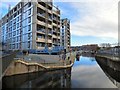
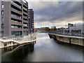
New Islington Marina, Rochdale Canal
This attractive facility complements the Ancoats Village regeneration nearby.
Image: © michael ely
Taken: 16 May 2014
0.02 miles
2
Cotton Field Wharf Apartments
New building at New Islington Marina off the Rochdale Canal.
Image: © Gerald England
Taken: 14 Jan 2017
0.02 miles
3
Just My Type
Moored at New Islington Marina.
Image: © Gerald England
Taken: 11 May 2021
0.02 miles
4
Ohie at New Islington Marina.
Moored opposite New Islington Free School with Murray Mills in the background.
Image: © Gerald England
Taken: 11 May 2021
0.02 miles
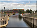
5
Narrow Miss and Ohie
Moored at New Islington Marina.
Image: © Gerald England
Taken: 11 May 2021
0.02 miles
6
Rochdale Canal, New Islington Branch
The link from the Rochdale Canal to the New Islington Marina.
Image: © David Dixon
Taken: 28 Nov 2017
0.02 miles
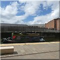
7
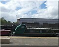
Canal repairs on the Rochdale canal at Ancoats
Image: © Ian S
Taken: 3 Sep 2011
0.02 miles
8
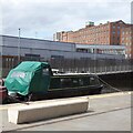
Finding Neilmo
Narrowboat moored at New Islington Marina.
Image: © Gerald England
Taken: 11 May 2021
0.02 miles
9
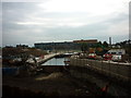
Rochdale Canal, New Islington
Looking towards the New Islington Marina from the bridge at Redhill Street.
New Islington is an inner city regeneration area of Manchester, historically a part of Ancoats district. A previous attempt to regenerate the area was made in the 1970s, and from then until the millennium, it was known as the Cardroom Estate (a reference to the number of former mills in the area).
The current development was one of several millennium village projects around the UK seeking to regenerate inner-city areas. When funding to redevelop the area was secured in 2002, the name New Islington was chosen as it was it was the original name for the area; the name appears on the 1840 Ordnance Survey map and there is also a street with that name.
The New Islington area is bounded by Great Ancoats Street (west), New Union Street and New Islington (north-east), Weybridge Road (east) and Pollard Street (south). There is also a Metrolink stop as part of the general expansion of the tram system. It will be the first stop on the new Piccadilly–Droylsden (and eventually Ashton) line and is situated adjacent to Pollard Street.
http://www.newislington.co.uk/ New Islington (Urban Splash)
Image: © David Dixon
Taken: 1 Sep 2012
0.02 miles
10
Narrow Miss and Ohie
Moored at New Islington Marina.
Image: © Gerald England
Taken: 11 May 2021
0.02 miles