IMAGES TAKEN NEAR TO
Naval Street, MANCHESTER, M4 6EW
Introduction
This page details the photographs taken nearby to Naval Street, M4 6EW by members of the Geograph project.
The Geograph project started in 2005 with the aim of publishing, organising and preserving representative images for every square kilometre of Great Britain, Ireland and the Isle of Man.

There are currently over 7.5m images from over14,400 individuals and you can help contribute to the project by visiting https://www.geograph.org.uk
Image Map
Images are licensed for reuse under creativecommons.org/licenses/by-sa/2.0
Notes
- Clicking on the map will re-center to the selected point.
- The higher the marker number, the further away the image location is from the centre of the postcode.
Image Listing (387 Images Found)
Images are licensed for reuse under creativecommons.org/licenses/by-sa/2.0
Image
Details
Distance
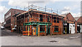
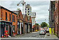
1

Radium Street facing south
In 1994, the building that had been Sankey's Soap Factory was converted to make a 3-storey nightclub. A special feature is its indoor beach made with 50 tonnes of sand imported from the Bahamas. In May 2013 it closed for the 3rd time, taking clubbers by surprise since it appeared to be very successful. There are three other Sankey's: Ibiza, Chicago and New York.
http://en.wikipedia.org/wiki/Sankeys_(nightclub)
Image: © Steve Nesbitt
Taken: 28 Jul 2013
0.02 miles
2
Ancoats
Building on the corner of Radium Street and Jersey Street. For an early view see Stephen Richards photograph Image
Image: © Peter McDermott
Taken: 28 Sep 2014
0.04 miles
3
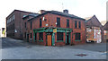
Former Cross Keys, Jersey Street, Manchester
Utilitarian former pub on the corner of the splendidly-named Radium Street. The presence of the satellite dish must mean it hasn't been closed for as long as looks would suggest. How many pints were sunk inside by local workers or residents I wonder? Answers on a postcard.
An application to demolish it in 2010 failed - it is the sort of building which stands in the way of urban regeneration and its grand visions (see the marketing slogans on the right, and the faux old paving).
By 2014, something was afoot: Image
Image: © Stephen Richards
Taken: 24 Jul 2011
0.05 miles
4
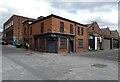
Corner of Radium Street and Jersey Street
The "Dance Bar" on the corner was originally a pub called the Cross Keys whose licence dated back to 1830. The original pub was situated about 50 yards further up Jersey Street and was briefly known as The Amalgamation. It was demolished in the late 19th century to make way for a brass foundry and so the Cross Keys set up on the corner of German Street, which was renamed to Radium Street in 1914. Tetley bought it from Taylors Eagle Brewery in 1922. It closed in 2010 and was earmarked for demolition. However it has survived and is used as offices.
Image: © Gerald England
Taken: 11 May 2021
0.05 miles
6
Jersey Street
View down Jersey Street in Ancoats.
Image: © Peter McDermott
Taken: 5 Aug 2024
0.05 miles
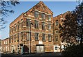
7
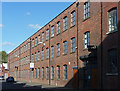
Flint Glass Works, Jersey Street, Manchester
Now small commercial units, the building's website records that from 1884-1914 it was occupied by Percival Vickers & Co Ltd, who produced flint glass, mostly for tableware.
Image: © Stephen Richards
Taken: 24 Jul 2011
0.06 miles
8
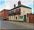
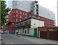
The Shamrock
According to Pubs of Manchester http://pubs-of-manchester.blogspot.co.uk/search/label/Shamrock%20-%20Bengal%20Street this quaint little back street pub halfway down Bengal Street (of Bengal Tigers infamy, as detailed in The Gangs of Manchester and the play Angels With Manky Faces) is the last remaining pub within Old Ancoats in an area that once housed an untold number of pubs.
Shown as a Wilsons house in 1962 http://www.images.manchester.gov.uk/web/objects/common/webmedia.php?irn=72326 by 1984 it was a Burtonwoods pub and is a Marstons house today [2010]. It was described in the Manchester Guardian in 1862 as "Vault, brewhouse, grocer's shop and dwelling house", belonging to Renshaw & Cardwell's Hulme brewery. As its name suggests, it was an Irish pub, where the Orangemen and Catholics of Ancoats would mix freely.
Nowadays it describe's itself http://www.shamrock-irishbar.co.uk/ as a hidden gem on the outskirts of the Northern Quarter with plasma screen showing all live Premiership Matches, a restaurant serving home cooked food and a beer garden.
Image
Image: © Gerald England
Taken: 14 Jan 2017
0.06 miles
9
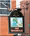
Sign of the Shamrock
Sign for the Shamrock Image
Image: © Gerald England
Taken: 14 Jan 2017
0.06 miles
10
The Shamrock
According to Pubs of Manchester http://pubs-of-manchester.blogspot.co.uk/search/label/Shamrock%20-%20Bengal%20Street this quaint little back street pub halfway down Bengal Street (of Bengal Tigers infamy, as detailed in The Gangs of Manchester and the play Angels With Manky Faces) was the last remaining pub within Old Ancoats in an area that once housed an untold number of pubs.
Shown as a Wilsons house in 1962 http://www.images.manchester.gov.uk/web/objects/common/webmedia.php?irn=72326 by 1984 it was a Burtonwoods pub and then a Marstons house in 2010. It was described in the Manchester Guardian in 1862 as "Vault, brewhouse, grocer's shop and dwelling house", belonging to Renshaw & Cardwell's Hulme brewery. As its name suggests, it was an Irish pub, where the Orangemen and Catholics of Ancoats would mix freely.
When photographed in 2017 Image its website described itself as a hidden gem on the outskirts of the Northern Quarter with plasma screen showing all live Premiership Matches, a restaurant serving home cooked food and a beer garden. It was closed by Marstons in 2018 and earmarked for demolition. Whatpub https://whatpub.com/pubs/MAN/9796/shamrock-inn-ancoats reports "It was bought by Holts in March 2019 who will be undertaking a major redevelopment but not until 2020." For the moment then it remains boarded up and its future uncertain.
Image
Image: © Gerald England
Taken: 11 May 2021
0.06 miles