IMAGES TAKEN NEAR TO
New Union Street, MANCHESTER, M4 6BW
Introduction
This page details the photographs taken nearby to New Union Street, M4 6BW by members of the Geograph project.
The Geograph project started in 2005 with the aim of publishing, organising and preserving representative images for every square kilometre of Great Britain, Ireland and the Isle of Man.

There are currently over 7.5m images from over14,400 individuals and you can help contribute to the project by visiting https://www.geograph.org.uk
Image Map
Images are licensed for reuse under creativecommons.org/licenses/by-sa/2.0
Notes
- Clicking on the map will re-center to the selected point.
- The higher the marker number, the further away the image location is from the centre of the postcode.
Image Listing (346 Images Found)
Images are licensed for reuse under creativecommons.org/licenses/by-sa/2.0
Image
Details
Distance
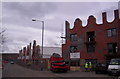
1
Housing at New Islington
Colourful frontages to houses on New Islington (the street of that name). What looks like an upper storey on one of the houses is actually not as at a closer look you can see straight through the false windows. The steps front left lead up to an arm of the New Islington Marina.
Image: © Gerald England
Taken: 9 Jan 2016
0.03 miles
2
New Islington
Unusual properties. Wonder what the designer was thinking!
Image: © Ian Paterson
Taken: 27 Jan 2015
0.04 miles
3
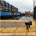
Investigative kitten
Whilst I was investigating New Islington Image a little kitten was busy investigating me.
Image: © Gerald England
Taken: 9 Jan 2016
0.04 miles
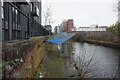
4
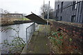
Rochdale Canal towards bridge #87A
At this point the towpath is / was blocked off to walkers.
Image: © Ian S
Taken: 2 Mar 2022
0.05 miles
5
Rochdale Canal towards bridge #87A
At this point the towpath is / was blocked off to walkers.
Image: © Ian S
Taken: 2 Mar 2022
0.05 miles
6
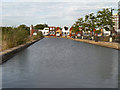
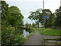
New Islington, Rochdale Canal
New Islington is an inner city regeneration area of Manchester, historically a part of Ancoats district. A previous attempt to regenerate the area was made in the 1970s, and from then until the millennium, it was known as the Cardroom Estate (a reference to the number of former mills in the area).
The current development was one of several millennium village projects around the UK seeking to regenerate inner-city areas. When funding to redevelop the area was secured in 2002, the name New Islington was chosen as it was it was the original name for the area; the name appears on the 1840 Ordnance Survey map and there is also a street with that name.
The New Islington area is bounded by Great Ancoats Street (west), New Union Street and New Islington (north-east), Weybridge Road (east) and Pollard Street (south). There is also a Metrolink stop as part of the general expansion of the tram system. It will be the first stop on the new Piccadilly–Droylsden (and eventually Ashton) line and is situated adjacent to Pollard Street.
http://www.newislington.co.uk/ New Islington (Urban Splash)
Image: © David Dixon
Taken: 1 Sep 2012
0.05 miles
7
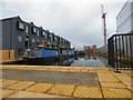
New Islington
The northerly arm of the New Islington Marina from New Islington (the street of that name). Narrowboats occupy moorings on the left by newly erected housing. Construction is now taking place on land to the right off New Union Street. Compare this view with one taken from the opposite direction in 2012 Image
Image: © Gerald England
Taken: 9 Jan 2016
0.05 miles
8
Amsterdam comes to Manchester
New social housing in Ancoats with a nod to Dutch rooflines.
http://traveldk.com/dkimages/0-amsterdam_master.jpg
Image: © S Parish
Taken: 27 Feb 2006
0.06 miles
10
Hedgehog at Ancoats
Narrowboat moored in an arm of the New Islington Marina. Building work between the marina and the Rochdale canal on land off New Union Street is continuing - compare with similar view in June 2015 Image
Image: © Gerald England
Taken: 9 Jan 2016
0.06 miles