IMAGES TAKEN NEAR TO
Corhampton Crescent, MANCHESTER, M46 9ST
Introduction
This page details the photographs taken nearby to Corhampton Crescent, M46 9ST by members of the Geograph project.
The Geograph project started in 2005 with the aim of publishing, organising and preserving representative images for every square kilometre of Great Britain, Ireland and the Isle of Man.

There are currently over 7.5m images from over14,400 individuals and you can help contribute to the project by visiting https://www.geograph.org.uk
Image Map
Images are licensed for reuse under creativecommons.org/licenses/by-sa/2.0
Notes
- Clicking on the map will re-center to the selected point.
- The higher the marker number, the further away the image location is from the centre of the postcode.
Image Listing (10 Images Found)
Images are licensed for reuse under creativecommons.org/licenses/by-sa/2.0
Image
Details
Distance
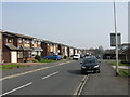
2
Atherton - Meadowbank Avenue, looking west
Image: © Peter Whatley
Taken: 24 Mar 2012
0.12 miles
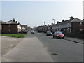
3
Atherton - Meadowbank Avenue, looking east
Image: © Peter Whatley
Taken: 24 Mar 2012
0.17 miles
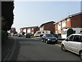
4
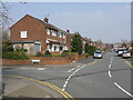
Hag Fold - Devonshire Road looking east at Car Bank Avenue
Image: © Peter Whatley
Taken: 24 Mar 2012
0.18 miles
5
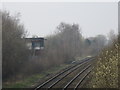
Atherton Goods Yard signalbox
The goods yard disappeared 50 years ago and the signalbox has been manned only for the rush-hours and unscheduled diversions for many years. Both it and the signalboxes at Walkden and Crow Nest Junction (Hindley) will disappear under a resignalling scheme planned for 2013.
Image: © Peter Whatley
Taken: 24 Mar 2012
0.19 miles
6
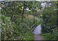
A footbridge on the Rotary Way
The Rotary Way is a footpath which broadly follows the boundary of Bolton MBC
http://www.ldwa.org.uk/ldp/members/show_path.php?path_name=Bolton+Rotary+Way+Footpath
Image: © Ian Greig
Taken: 21 Sep 2012
0.20 miles
7
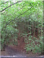
New Park Wood
The foreground & path below clearly show that this wood has a base of coal waste - it was planted on the remnants of a pit & slagheaps.
Image: © C Gallimore
Taken: Unknown
0.20 miles
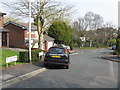
8
Atherton - Upton Road at Springfield Road
Image: © Peter Whatley
Taken: 24 Mar 2012
0.20 miles

10

Track in Hulton Park
Heading towards Park End Farm. There is a capped mine shaft by the track probably associated with Hulton Colliery Bank Pits, possibly an air vent since the colliery pit heads were further to the west of this track.
Image: © Kevin Waterhouse
Taken: 15 Aug 2023
0.25 miles