IMAGES TAKEN NEAR TO
Bolton Road, MANCHESTER, M46 9LF
Introduction
This page details the photographs taken nearby to Bolton Road, M46 9LF by members of the Geograph project.
The Geograph project started in 2005 with the aim of publishing, organising and preserving representative images for every square kilometre of Great Britain, Ireland and the Isle of Man.

There are currently over 7.5m images from over14,400 individuals and you can help contribute to the project by visiting https://www.geograph.org.uk
Image Map
Images are licensed for reuse under creativecommons.org/licenses/by-sa/2.0
Notes
- Clicking on the map will re-center to the selected point.
- The higher the marker number, the further away the image location is from the centre of the postcode.
Image Listing (31 Images Found)
Images are licensed for reuse under creativecommons.org/licenses/by-sa/2.0
Image
Details
Distance
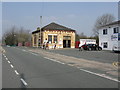
1

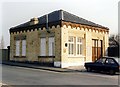
Atherton station - exterior view
The station building was built to a standard pattern for the new, direct route to Wigan and Liverpool Exchange of the former Lancashire and Yorkshire Railway. The large enamelled plate above the car on the right still carries the name Atherton Central station. Note the number of crossbars on the telegraph pole, indicative of the amount of railway communications circuits once required. For a view 35 years on, see: http://www.geograph.org.uk/photo/2864364.
Image: © Peter Whatley
Taken: Unknown
0.02 miles
2
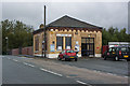
Atherton station building
One of the standard structures for the Atherton line, built by the Lancashire and Yorkshire Railway and given a sympathetic updating by Greater Manchester PTE in the 1980s.
Image: © Peter Whatley
Taken: 9 Feb 1989
0.02 miles
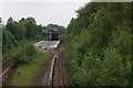
4

Atherton Station
Manchester to the left, Wigan to the right.
Image: © Gerald England
Taken: 18 Jan 2020
0.03 miles
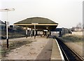
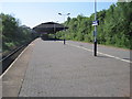
6
Atherton station from the footbridge
Unusually for the "new" Manchester-Wigan line, Atherton boasted a central island platform and two side platforms. Only the former remains in use. The signal is at clear as the signalbox is usually switched out, the block section then being between Walkden and Crow Nest Junction (Hindley).
Image: © Peter Whatley
Taken: 24 Mar 2012
0.03 miles
7
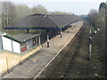
Atherton railway station
Instantly recognisable even after 35 years, though the cars have changed a bit. See: http://www.geograph.org.uk/photo/1011879. Chimneys have been capped and reduced in height, but the station remained manned on a Saturday afternoon and services were all heavily used.
Image: © Peter Whatley
Taken: 24 Mar 2012
0.03 miles
8
Atherton railway station, Greater Manchester
Opened in 1888 by the Lancashire & Yorkshire Railway on its line from Manchester to Wigan, Southport and Liverpool. View west towards Wigan Wallgate. Compare with Peter Whatley's photos from a similar position. The station is half the size and woodland has been allowed to appear on either side.
Image: © Nigel Thompson
Taken: 30 Apr 2011
0.03 miles
9
Atherton railway station
Viewed from Bolton Road. The station is on the line between Manchester and Southport. It is a bit of a walk from the town centre.
Image: © Bill Boaden
Taken: 15 Jun 2020
0.04 miles
10
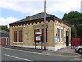
Atherton - station building
On Upton Road. For an alternative view, please see Image
Image: © Dave Bevis
Taken: 9 Sep 2014
0.04 miles