IMAGES TAKEN NEAR TO
Warwick Road, MANCHESTER, M46 9GE
Introduction
This page details the photographs taken nearby to Warwick Road, M46 9GE by members of the Geograph project.
The Geograph project started in 2005 with the aim of publishing, organising and preserving representative images for every square kilometre of Great Britain, Ireland and the Isle of Man.

There are currently over 7.5m images from over14,400 individuals and you can help contribute to the project by visiting https://www.geograph.org.uk
Image Map
Images are licensed for reuse under creativecommons.org/licenses/by-sa/2.0
Notes
- Clicking on the map will re-center to the selected point.
- The higher the marker number, the further away the image location is from the centre of the postcode.
Image Listing (4 Images Found)
Images are licensed for reuse under creativecommons.org/licenses/by-sa/2.0
Image
Details
Distance
3
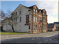
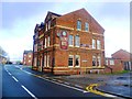
Railway Hotel
The Railway Hotel is situated on Bag Lane, opposite the site of the former Bag Lane Station. The line and station were closed in the 1960s, and the Railway Hotel is now the only reminder that a railway once existed here.
Image: © David Dixon
Taken: 8 Feb 2012
0.25 miles
4
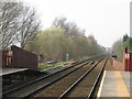
Railway Bridge, Spa Road, Hag Fold
Hag Fold Station is to the right.
Image: © Stephen Armstrong
Taken: 14 Aug 2010
0.25 miles