IMAGES TAKEN NEAR TO
Tyldesley Old Road, MANCHESTER, M46 9EH
Introduction
This page details the photographs taken nearby to Tyldesley Old Road, M46 9EH by members of the Geograph project.
The Geograph project started in 2005 with the aim of publishing, organising and preserving representative images for every square kilometre of Great Britain, Ireland and the Isle of Man.

There are currently over 7.5m images from over14,400 individuals and you can help contribute to the project by visiting https://www.geograph.org.uk
Image Map
Images are licensed for reuse under creativecommons.org/licenses/by-sa/2.0
Notes
- Clicking on the map will re-center to the selected point.
- The higher the marker number, the further away the image location is from the centre of the postcode.
Image Listing (32 Images Found)
Images are licensed for reuse under creativecommons.org/licenses/by-sa/2.0
Image
Details
Distance
1
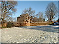
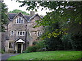
Chanters Farm, Atherton
Chanters is a 17th century farmhouse on the bank of a brook running down The Valley in Atherton, near the site of an old ford. The 'Chanters' traditionally refers to a medieval chantry that was once near the site.
Image: © Margaret Clough
Taken: 26 Dec 2004
0.02 miles
2
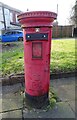
Elizabeth II postbox on Tyldesley Road
Postbox No. M46 266.
Currently out of use.
See Image] for context.
Image: © JThomas
Taken: 9 Mar 2024
0.10 miles
3
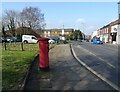
Tyldesley Road, Atherton (A577)
Showing position of Postbox No. M46 266.
See Image] for postbox.
Image: © JThomas
Taken: 9 Mar 2024
0.11 miles
4
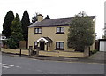
House with a porch
On Miller's Lane, Atherton.
Image: © Phil Platt
Taken: 14 Apr 2011
0.12 miles
5
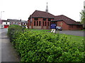
Atherton Baptist Church
On Tyldesley Road in the centre of Atherton.
Image: © Phil Platt
Taken: 14 Apr 2011
0.13 miles
6
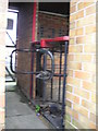
Turnstile at Atherton Collieries AFC ground
Image: © C Gallimore
Taken: 25 Sep 2007
0.15 miles
7
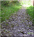
Cobbled path through The Valley
I suppose this footpath may once have been the main road from Chowbent to Hindsford.
Image: © C Gallimore
Taken: 25 Sep 2007
0.15 miles
8
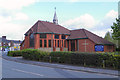
Atherton Baptist Church, Tyldesley Road
Image: © David Dixon
Taken: 11 May 2012
0.15 miles
9
Alder House
This house used to be the local baby clinic, but is now once again a private residence.
Image: © C Gallimore
Taken: 25 Sep 2007
0.16 miles
10
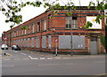
Derelict Mill
On the corner of Tyldesley Road and Lee Street, Atherton. The building is up for sale...
Image: © Phil Platt
Taken: 14 Apr 2011
0.16 miles