IMAGES TAKEN NEAR TO
Tyldesley Road, MANCHESTER, M46 9AD
Introduction
This page details the photographs taken nearby to Tyldesley Road, M46 9AD by members of the Geograph project.
The Geograph project started in 2005 with the aim of publishing, organising and preserving representative images for every square kilometre of Great Britain, Ireland and the Isle of Man.

There are currently over 7.5m images from over14,400 individuals and you can help contribute to the project by visiting https://www.geograph.org.uk
Image Map
Images are licensed for reuse under creativecommons.org/licenses/by-sa/2.0
Notes
- Clicking on the map will re-center to the selected point.
- The higher the marker number, the further away the image location is from the centre of the postcode.
Image Listing (10 Images Found)
Images are licensed for reuse under creativecommons.org/licenses/by-sa/2.0
Image
Details
Distance
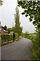
1
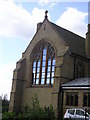
Tyldesley Road Hindsford
The church is the former St. Anne now converted into flats
Image: © Raymond Knapman
Taken: 24 Jun 2011
0.04 miles
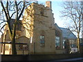
2
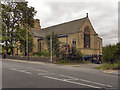
St Anne's Parish Church, Hindsford
The parish of Hindsford became independent from Atherton parish in 1884 and in 1889 the foundation stone for St Anne's Church was laid. The church was completed in 1901.
In 1999, the Atherton and Hindsford parishes were recombined and St Anne’s church was closed and later deconsecrated. The Grade II listed building was converted into luxury apartments in 2005.
Image: © David Dixon
Taken: 30 Aug 2011
0.05 miles
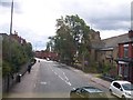
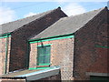
3
Chanters House (corner of Tyldesley Road/ Tyldesley Old Road)
This building,(according to the sign on the front) is now an "Early Years & Families Resource Centre"...
Image: © C Gallimore
Taken: 25 Sep 2007
0.06 miles
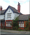
4
St Annes apartments
Ex-church, now flats (or "Luxury Apartments", in sales-speak!).
Image: © C Gallimore
Taken: 25 Sep 2007
0.09 miles
5
St. Anne's church, Hindsford
This church has been recently converted into luxury apartments.
Image: © Margaret Clough
Taken: 4 Jan 2006
0.09 miles
6
The old St Anne's Mission Chapel on Arley Way
This chapel was replaced in early 1900s by the new church on Tyldesley Road; this building is now part of Chanters Industrial Estate on Arley Way and the new church is now converted to flats!
Image: © C Gallimore
Taken: 25 Sep 2007
0.14 miles
8
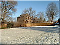
Chanters Farm, Atherton
Chanters is a 17th century farmhouse on the bank of a brook running down The Valley in Atherton, near the site of an old ford. The 'Chanters' traditionally refers to a medieval chantry that was once near the site.
Image: © Margaret Clough
Taken: 26 Dec 2004
0.18 miles
9
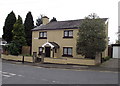
House with a porch
On Miller's Lane, Atherton.
Image: © Phil Platt
Taken: 14 Apr 2011
0.23 miles