IMAGES TAKEN NEAR TO
Coal Pit Lane, MANCHESTER, M46 0UA
Introduction
This page details the photographs taken nearby to Coal Pit Lane, M46 0UA by members of the Geograph project.
The Geograph project started in 2005 with the aim of publishing, organising and preserving representative images for every square kilometre of Great Britain, Ireland and the Isle of Man.

There are currently over 7.5m images from over14,400 individuals and you can help contribute to the project by visiting https://www.geograph.org.uk
Image Map
Images are licensed for reuse under creativecommons.org/licenses/by-sa/2.0
Notes
- Clicking on the map will re-center to the selected point.
- The higher the marker number, the further away the image location is from the centre of the postcode.
Image Listing (12 Images Found)
Images are licensed for reuse under creativecommons.org/licenses/by-sa/2.0
Image
Details
Distance


4

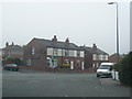
St. George's church, Atherton and medical centre.
St. George's infant school used to be where the new medical centre is now.
Image: © Margaret Clough
Taken: 11 Jan 2006
0.16 miles
5

Ena Mill, Atherton
Once a cotton mill, now a business centre and factory outlet.
Image: © Margaret Clough
Taken: 15 Dec 2005
0.17 miles
6

Atherton Cemetery
The northern end of the cemetery where the graves are newer.
Image: © Bill Boaden
Taken: 15 Jun 2020
0.18 miles

8

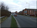
Lambeth Street
A residential street near the town centre.
Image: © Bill Boaden
Taken: 15 Jun 2020
0.20 miles
10
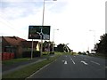
A577, Wigan Road
Approaching the A579, Atherleigh Way roundabout.
Image: © Stephen Armstrong
Taken: 5 Aug 2011
0.22 miles