IMAGES TAKEN NEAR TO
Sumner Street, MANCHESTER, M46 0LA
Introduction
This page details the photographs taken nearby to Sumner Street, M46 0LA by members of the Geograph project.
The Geograph project started in 2005 with the aim of publishing, organising and preserving representative images for every square kilometre of Great Britain, Ireland and the Isle of Man.

There are currently over 7.5m images from over14,400 individuals and you can help contribute to the project by visiting https://www.geograph.org.uk
Image Map
Images are licensed for reuse under creativecommons.org/licenses/by-sa/2.0
Notes
- Clicking on the map will re-center to the selected point.
- The higher the marker number, the further away the image location is from the centre of the postcode.
Image Listing (30 Images Found)
Images are licensed for reuse under creativecommons.org/licenses/by-sa/2.0
Image
Details
Distance
2
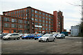
Howe Bridge Mills, Atherton
A large complex of cotton spinning mills developed from the 1870s to the 1920s and remaining in textile production until 1999. Also on site is Unit 1 from 1978 that was probably the only new building for cotton spinning since the 1920s but not distinguishable from other modern industrial buildings.
This site has now been cleared and the positions are based on my earlier submission. Demolition occurred in 2014 and houses now stand on this site.
Image: © Chris Allen
Taken: 23 Jan 2011
0.13 miles

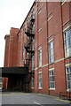
4
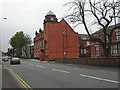
Atherton Town Hall
On Bolton Road; seat of Atherton Urban District Council until 1974; now municipal buildings for Wigan MBC.
Image: © Mike Faherty
Taken: 18 Oct 2009
0.13 miles
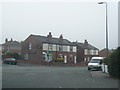
6
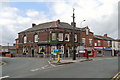
The Punch Bowl
Public house at the junction of Leigh Road (B5215), Wigan Road (A577) and Market Street at Atherton.
Image: © David Dixon
Taken: 11 May 2012
0.14 miles
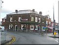
7
Ena Mill, Atherton
A very complete Edwardian spinning mill built in 1908 of red and yellow brick with terracotta decoration. This is a spectacular survivor that is now in other retail usage. It is a grade II listed building.
Image: © Chris Allen
Taken: 23 Jan 2011
0.16 miles
8
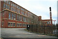
Ena Mill, Atherton
A very complete Edwardian spinning mill built in 1908 of red and yellow brick with terracotta decoration. This is a spectacular survivor that is now in other retail usage. It is a grade II listed building. The railings on the right are in front of the mill's lodge (condenser cooling water pond) and this is in itself a now unusual survivor. The projecting building in front of the chimney is the former engine house and I think this almost certainly contained a horizontal four cylinder engine with rope drive. I have been unable to find out anything about this engine.
Image: © Chris Allen
Taken: 23 Jan 2011
0.16 miles
9
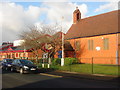
St. George's church, Atherton and medical centre.
St. George's infant school used to be where the new medical centre is now.
Image: © Margaret Clough
Taken: 11 Jan 2006
0.17 miles
10

Atherton Mosaic
Designed by local school children
Image: © Dave Green
Taken: 25 May 2007
0.17 miles