IMAGES TAKEN NEAR TO
Second Avenue, MANCHESTER, M46 0JA
Introduction
This page details the photographs taken nearby to Second Avenue, M46 0JA by members of the Geograph project.
The Geograph project started in 2005 with the aim of publishing, organising and preserving representative images for every square kilometre of Great Britain, Ireland and the Isle of Man.

There are currently over 7.5m images from over14,400 individuals and you can help contribute to the project by visiting https://www.geograph.org.uk
Image Map
Images are licensed for reuse under creativecommons.org/licenses/by-sa/2.0
Notes
- Clicking on the map will re-center to the selected point.
- The higher the marker number, the further away the image location is from the centre of the postcode.
Image Listing (19 Images Found)
Images are licensed for reuse under creativecommons.org/licenses/by-sa/2.0
Image
Details
Distance
4
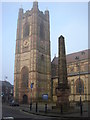
St. John, Atherton and obelisk
St. Johns built 1879 at a cost of £24,000. Obelisk erected in market place 1781 by Robert Vernon Atherton, rebuilt 1867 and renovated 1960.
Image: © Margaret Clough
Taken: 13 Dec 2005
0.16 miles
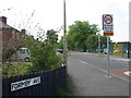
5
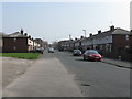
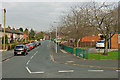
Hag Fold - Devonshire Road looking east at Car Bank Avenue
Image: © Peter Whatley
Taken: 24 Mar 2012
0.16 miles
6
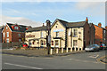
The Spinners Arms
The Spinners Arms public house on Bolton Road (A579) at Atherton.
Image: © David Dixon
Taken: 8 Feb 2012
0.17 miles
7
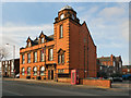
Atherton Town Hall
The town hall on Bolton Road (A579).
Image: © David Dixon
Taken: 8 Feb 2012
0.18 miles
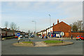
8
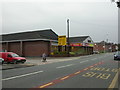
Atherton, supermarket
Netto, on Bolton Road.
Image: © Mike Faherty
Taken: 18 Oct 2009
0.19 miles
9
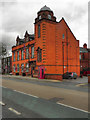
Atherton Town Hall
The Town Hall, on Bolton Road (A579).
Image: © David Dixon
Taken: 30 Aug 2011
0.19 miles