IMAGES TAKEN NEAR TO
Cambridge Street, MANCHESTER, M46 0BX
Introduction
This page details the photographs taken nearby to Cambridge Street, M46 0BX by members of the Geograph project.
The Geograph project started in 2005 with the aim of publishing, organising and preserving representative images for every square kilometre of Great Britain, Ireland and the Isle of Man.

There are currently over 7.5m images from over14,400 individuals and you can help contribute to the project by visiting https://www.geograph.org.uk
Image Map
Images are licensed for reuse under creativecommons.org/licenses/by-sa/2.0
Notes
- Clicking on the map will re-center to the selected point.
- The higher the marker number, the further away the image location is from the centre of the postcode.
Image Listing (41 Images Found)
Images are licensed for reuse under creativecommons.org/licenses/by-sa/2.0
Image
Details
Distance
4
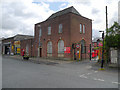
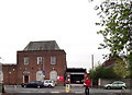
Atherton Delivery Office, Crab Tree Lane
Image: © David Dixon
Taken: 11 May 2012
0.09 miles
5
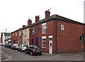
Victorian Terraced Housing
A short row of houses built during the reign of Queen Victoria. A name plate on the second house along (not visible) reads "Jubilee Terrace 1897".
Image: © Phil Platt
Taken: 14 Apr 2011
0.09 miles
7
Atherton Royal Mail Delivery Office
Complete with a postie!
Image: © Phil Platt
Taken: 14 Apr 2011
0.10 miles
8
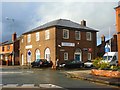
Dental Practice - Hamilton Street, Atherton
Image: © Anthony Parkes
Taken: 9 Dec 2011
0.10 miles
9
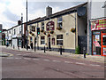
Mountain Dew
Public House on Market Street, Atherton.
Image: © David Dixon
Taken: 11 May 2012
0.10 miles
10
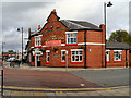
The Jolly Nailor
Public house at the corner of Market Street and Crab Tree Lane in Atherton.
Image: © David Dixon
Taken: 11 May 2012
0.11 miles