IMAGES TAKEN NEAR TO
Wardour Street, MANCHESTER, M46 0BA
Introduction
This page details the photographs taken nearby to Wardour Street, M46 0BA by members of the Geograph project.
The Geograph project started in 2005 with the aim of publishing, organising and preserving representative images for every square kilometre of Great Britain, Ireland and the Isle of Man.

There are currently over 7.5m images from over14,400 individuals and you can help contribute to the project by visiting https://www.geograph.org.uk
Image Map
Images are licensed for reuse under creativecommons.org/licenses/by-sa/2.0
Notes
- Clicking on the map will re-center to the selected point.
- The higher the marker number, the further away the image location is from the centre of the postcode.
Image Listing (31 Images Found)
Images are licensed for reuse under creativecommons.org/licenses/by-sa/2.0
Image
Details
Distance
1
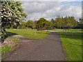
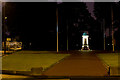
Central Park, Atherton
Central Park is a public park covering an area of approx 10 acres. It was established in 1912.
Image: © David Dixon
Taken: 11 May 2012
0.08 miles
2
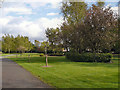
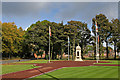
Atherton, Central Park
Central Park, a 10-acre public park, was created in 1912.
Image: © David Dixon
Taken: 11 May 2012
0.10 miles
3
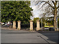
Central Park Gates
The entrance to Central Park at the corner of Bee Fold Lane and Leigh Road.
Image: © David Dixon
Taken: 11 May 2012
0.15 miles
5

Atherton Mosaic
Designed by local school children
Image: © Dave Green
Taken: 25 May 2007
0.16 miles
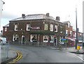
9
The Punch Bowl
Public house at the junction of Leigh Road (B5215), Wigan Road (A577) and Market Street at Atherton.
Image: © David Dixon
Taken: 11 May 2012
0.18 miles
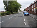
10
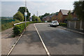
Summerhill Park
A new housing estate which has left Bee Fold Lane as a small track on the left.
Image: © Bill Boaden
Taken: 15 Jun 2020
0.18 miles