IMAGES TAKEN NEAR TO
Thompson Street, MANCHESTER, M4 5FP
Introduction
This page details the photographs taken nearby to Thompson Street, M4 5FP by members of the Geograph project.
The Geograph project started in 2005 with the aim of publishing, organising and preserving representative images for every square kilometre of Great Britain, Ireland and the Isle of Man.

There are currently over 7.5m images from over14,400 individuals and you can help contribute to the project by visiting https://www.geograph.org.uk
Image Map
Images are licensed for reuse under creativecommons.org/licenses/by-sa/2.0
Notes
- Clicking on the map will re-center to the selected point.
- The higher the marker number, the further away the image location is from the centre of the postcode.
Image Listing (347 Images Found)
Images are licensed for reuse under creativecommons.org/licenses/by-sa/2.0
Image
Details
Distance
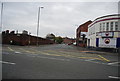
1
Manchester Central fire station
Manchester Central fire station, Thompson Street, Manchester, Greater Manchester
Image: © Kevin Hale
Taken: 30 Oct 2007
0.02 miles
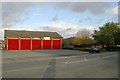
2
Former Police station
Former police & fire station prior to demolition.
Image: © Phill
Taken: 27 May 2003
0.05 miles
3
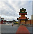
Wing Yip
The Manchester branch of Wing Yip on the corner of Oldham Road and Thompson Street.
According to the company website http://www.wingyip.com/#CompanyHistory "Wing Yip is widely recognised as the UK's leading Oriental grocer with four sites - Birmingham, Manchester, Croydon and Cricklewood." Mr Wing Yip and business partners opened their first Chinese restaurant in Clacton-on-Sea in the 1960s. In the 1970s he and his brothers opened their first specialised Chinese grocery store in Birmingham and then Manchester.
Note: Photograph is for record purposes only. The photographer has no connection with the business depicted.
Image: © Gerald England
Taken: 14 Jan 2017
0.07 miles
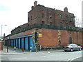
4
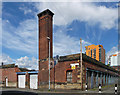
Former police and fire station, Goulden Street, Manchester
'Former' being the operative word. Either directly or indirectly, as a result of a fire in 2002 the site has largely been cleared. The channelled chimney (perhaps saved by the listing) looms over the local grid of small streets mostly comprised of empty plots of land which have been turned into modest (and cheap) car parks, and low-rise sheds. Originally built c1870 by the Borough Surveyor, J.G. Lynde. Grade II listed.
Image: © Stephen Richards
Taken: 24 Jun 2011
0.07 miles
5
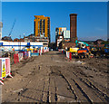
Goulden Street
The Lancastrian development site in Manchester.
Image: © Peter McDermott
Taken: 15 Jul 2018
0.08 miles
8
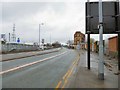
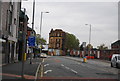
Rochdale Road
The A664 out of Manchester.
Image: © Gerald England
Taken: 1 Apr 2017
0.09 miles
9
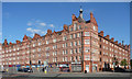
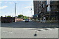
Victoria Square, Oldham Road, Manchester
Built by Spalding & Cross for the Manchester Corporation in 1897, replacing slums, the first such housing project and still public housing. Quadrangular with a courtyard and greenery inside. Pevsner picks out the good brickwork, and the decorative touches such as the gables and terracotta details. Grade II listed.
Sadly, despite the architects' best efforts, Pevsner reports that "the initiative did not do the slum dwellers any good since they could not afford the rents and had to move to squalid conditions elsewhere."
Image: © Stephen Richards
Taken: 24 Jul 2011
0.09 miles