IMAGES TAKEN NEAR TO
Mather Avenue, MANCHESTER, M45 8XS
Introduction
This page details the photographs taken nearby to Mather Avenue, M45 8XS by members of the Geograph project.
The Geograph project started in 2005 with the aim of publishing, organising and preserving representative images for every square kilometre of Great Britain, Ireland and the Isle of Man.

There are currently over 7.5m images from over14,400 individuals and you can help contribute to the project by visiting https://www.geograph.org.uk
Image Map
Images are licensed for reuse under creativecommons.org/licenses/by-sa/2.0
Notes
- Clicking on the map will re-center to the selected point.
- The higher the marker number, the further away the image location is from the centre of the postcode.
Image Listing (11 Images Found)
Images are licensed for reuse under creativecommons.org/licenses/by-sa/2.0
Image
Details
Distance
1
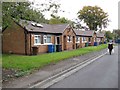
Elms Close
Part of the Elms Farm Estate. It is a great pity that no solution has been found to the problem of storing the wheeled bins favoured by local authorities today, and they are an absolute blight on so many landscapes.
Image: © Jonathan Wilkins
Taken: 22 Oct 2016
0.06 miles
2
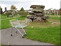
Adventure playground
An artful and unusual facility in the adventure playground is this stack of well-bedded, Carboniferous sandstone blocks - a grand challenge for children less able to enjoy the dangers of cliffs and quarry outcrops! Further adventure provided by nicking trolleys from Morrisons supermarket?
Image: © Jonathan Wilkins
Taken: 22 Oct 2016
0.11 miles
3
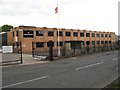
Danish Crown warehouse and offices
The office frontage on Stanley Road of this importer of Danish bacon and pork products.
Image: © Jonathan Wilkins
Taken: 22 Oct 2016
0.19 miles
4
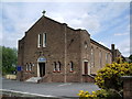
The Church of Jesus Christ of Latter-Day Saints, Whitefield
Image: © Alexander P Kapp
Taken: 10 May 2007
0.19 miles

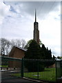
6
St Bernadette's Catholic Church, Whitefield
Image: © Alexander P Kapp
Taken: 10 May 2007
0.23 miles
7
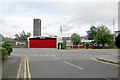
Whitefield fire station
Whitefield fire station, Bury New Road, Whitefield, Greater Manchester
Image: © Kevin Hale
Taken: 29 Jul 2010
0.23 miles
8
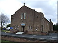
St Bernadette's Catholic Church, Whitefield
Image: © JThomas
Taken: 16 Mar 2013
0.23 miles
10
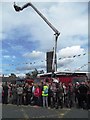
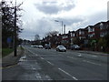
Whitefield Fire Station (with Olympic Torch Crowds)
Image: © Anthony Parkes
Taken: 23 Jun 2012
0.24 miles