IMAGES TAKEN NEAR TO
Stanley Road, MANCHESTER, M45 8QX
Introduction
This page details the photographs taken nearby to Stanley Road, M45 8QX by members of the Geograph project.
The Geograph project started in 2005 with the aim of publishing, organising and preserving representative images for every square kilometre of Great Britain, Ireland and the Isle of Man.

There are currently over 7.5m images from over14,400 individuals and you can help contribute to the project by visiting https://www.geograph.org.uk
Image Map
Images are licensed for reuse under creativecommons.org/licenses/by-sa/2.0
Notes
- Clicking on the map will re-center to the selected point.
- The higher the marker number, the further away the image location is from the centre of the postcode.
Image Listing (9 Images Found)
Images are licensed for reuse under creativecommons.org/licenses/by-sa/2.0
Image
Details
Distance
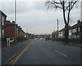
1

Danish Crown warehouse and offices
The office frontage on Stanley Road of this importer of Danish bacon and pork products.
Image: © Jonathan Wilkins
Taken: 22 Oct 2016
0.08 miles
3
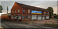
Whitefield
Industrial building on Albert Close Industrial Estate.
Image: © Peter McDermott
Taken: 11 Jun 2020
0.19 miles
4

Whitefield Park Bowling Greens
Whitefield Park is a small urban local community park which was first opened as a public park in 1890. It is located opposite Morrisons supermarket on Stanley Road, next to Whitefield Metrolink tram station. The park has two crown green bowling greens and two pavilions which are used by the Whitefield Park Bowling Club.
Image: © David Dixon
Taken: 18 Jul 2019
0.21 miles
5

Statue in Whitefield Park
This statue stands at the back of the bowling greens in Whitefield Park. I do not know the origins of the statue but it may have been rescued from one of the large houses in the area which were demolished during the twentieth century.
Image: © David Dixon
Taken: 18 Jul 2019
0.21 miles
6

Statue at Whitefield Park Bowling Club
This statue stands at the back of the bowling greens in Whitefield Park. I do not know the origins of the statue but it may have been rescued from one of the large houses in the area which were demolished during the twentieth century.
Image: © David Dixon
Taken: 18 Jul 2019
0.21 miles
7
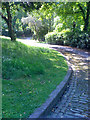
Top of Whitefield Park hill
High on the hill of Whitefield Park, looking down the eastern fork in the cobbled path, back towards the entrance gate. The path is quite steep, which is countered by the raised-edge cobbles, which presumably helped the Victorian-era horses keep their footing during rain or snow.
Image: © Salford Sal
Taken: 9 Jul 2011
0.23 miles
8
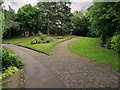
Diverging Paths in Whitefield Park
Whitefield Park is a small urban local community park which was first opened as a public park in 1890. It is located opposite Morrisons supermarket on Stanley Road, next to Whitefield Metrolink tram station. The area at the back of the park is planted with trees and wildflowers.
Image: © David Dixon
Taken: 18 Jul 2019
0.24 miles
9
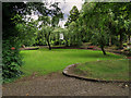
Whitefield Park
Whitefield Park is a small urban local community park which was first opened as a public park in 1890. It is located opposite Morrisons supermarket on Stanley Road, next to Whitefield Metrolink tram station. The area at the back of the park is planted with trees and wildflowers.
Image: © David Dixon
Taken: 18 Jul 2019
0.25 miles