IMAGES TAKEN NEAR TO
Corday Lane, MANCHESTER, M45 8ED
Introduction
This page details the photographs taken nearby to Corday Lane, M45 8ED by members of the Geograph project.
The Geograph project started in 2005 with the aim of publishing, organising and preserving representative images for every square kilometre of Great Britain, Ireland and the Isle of Man.

There are currently over 7.5m images from over14,400 individuals and you can help contribute to the project by visiting https://www.geograph.org.uk
Image Map
Images are licensed for reuse under creativecommons.org/licenses/by-sa/2.0
Notes
- Clicking on the map will re-center to the selected point.
- The higher the marker number, the further away the image location is from the centre of the postcode.
Image Listing (23 Images Found)
Images are licensed for reuse under creativecommons.org/licenses/by-sa/2.0
Image
Details
Distance
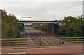
1
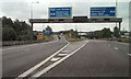
M66, Simister Island
The southbound M66 at the Simister Island junction with the M62 and M60. At the other side of the junction, the M66 becomes part of the Manchester Outer Ring Road (M60)
Image: © David Dixon
Taken: 20 Jul 2010
0.07 miles
2
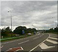
M66 Northbound
Sliproad to the M66 at Simister Island.
Image: © Gerald England
Taken: 22 Aug 2008
0.11 miles
3

Slip to M66
The sliproad to the M66 from the M60 at Simister.
Image: © Gerald England
Taken: 22 Aug 2008
0.16 miles
5
Inside Simister Island
At junction 18 of the M60/M62. The Eastbound carriageway can be seen crossing over the traffic-light controlled roundabout which right-turning traffic needs to negotiate. The inside of the roundabout host a profusion of wild flowers.
Image: © Gerald England
Taken: 10 Jun 2010
0.19 miles
6

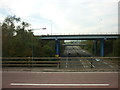
Simister Island in Fog
The bridges carrying the Simister Island junction and the M62 motorway over the M60/M66 at Simister on a foggy Saturday.
Image: © David Dixon
Taken: 23 Jan 2010
0.19 miles
7

M60, M62, M66 Junction (Simister Island)
The interchange between the M60 (Manchester Outer Ring Road), M66 and M62 Motorways at Simister. Looking from the M60 eastern section. Straight on, the road changes to the M66 towards Bury. To the left, traffic follows the M60 western section or travels round the island to the eastbound M62 towards Yorkshire. Simister Island is junction 18 of the M62/M60 and junction 4 of the M66.
Image: © David Dixon
Taken: 23 Jan 2010
0.19 miles
8
Junction 18
The motorway passing under the bridge is the M66 from Bury changing into the M60 towards Stockport. Taken from the bridge carrying traffic moving either from the M60 Northbound to the M62 Eastbound or from the M60 Eastbound to the M60 Southbound. The next bridge in sight takes the main M62 motorway carriageways over the junction. The next is carrying traffic either from the M66 Southbound to the M60 Westbound or the M62 Westbound to the M66 Northbound. The bridge in the background carries the minor road, Simister Lane over the M60.
Image: © Gerald England
Taken: 10 Jun 2010
0.19 miles
9

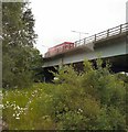
Simister Island
The busy interchange between motorways M60/M62 and M66 at Simister, viewed from the bridge at Simister Lane.
Image: © David Dixon
Taken: 17 Feb 2012
0.20 miles
10

Simister
The M60/M66/M62 Interchange near Simister.
Image: © Peter McDermott
Taken: 16 Mar 2014
0.20 miles