IMAGES TAKEN NEAR TO
Higher Lane, MANCHESTER, M45 7WH
Introduction
This page details the photographs taken nearby to Higher Lane, M45 7WH by members of the Geograph project.
The Geograph project started in 2005 with the aim of publishing, organising and preserving representative images for every square kilometre of Great Britain, Ireland and the Isle of Man.

There are currently over 7.5m images from over14,400 individuals and you can help contribute to the project by visiting https://www.geograph.org.uk
Image Map
Images are licensed for reuse under creativecommons.org/licenses/by-sa/2.0
Notes
- Clicking on the map will re-center to the selected point.
- The higher the marker number, the further away the image location is from the centre of the postcode.
Image Listing (58 Images Found)
Images are licensed for reuse under creativecommons.org/licenses/by-sa/2.0
Image
Details
Distance
1
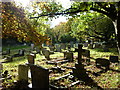
All Saints, Stand
This is a section of the churchyard of All Saints, Stand, in Whitefield, Manchester. Higher Lane is discernible beyond the background trees.
Image: © Carroll Pierce
Taken: 27 Oct 2012
0.04 miles
2

Stand Cricket Club
Cricket club located in Whitefield, Bury. The sign above the door of the hut to the right reads "Bury Sub Aqua Club". Perhaps flooding of the pitch is a problem!
Image: © Keith Williamson
Taken: 18 Jan 2006
0.05 miles
3
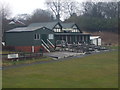
Stand Cricket Club - Pavilion
The pavilion at Stand CC. The club runs two teams in the Lancashire County League and a third XI in the Manchester & District Cricket Association.
Image: © BatAndBall
Taken: 8 Mar 2013
0.05 miles
4
Stand War Memorial
This is at the western end of All Saints churchyard.
Image: © Bill Boaden
Taken: 26 Jul 2011
0.06 miles

6
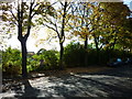
Hamilton Road, Whitefield
Taken on Hamilton Road in Whitefield, north Manchester, Stand Cricket Club is discernible just beyond the tree line.
Image: © Carroll Pierce
Taken: 27 Oct 2012
0.07 miles
7
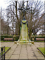
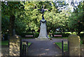
Whitefield War Memorial
The War memorial and memorial garden on Higher Lane. Behind the memorial is All Saints Parish Church and its graveyard.
The inscription on the memorial reads:
IN GRATEFUL MEMORY
OF
THE MEN OF WHITEFIELD
WHO
IN THE GREAT WAR
GAVE THEIR LIVES
FOR
THEIR COUNTRY
AD 1914 - 1918
"THEIR NAME LIVETH FOR EVERMORE"
ECCLESIASTICUS XLIV.14
Image]
Image: © David Dixon
Taken: 6 Mar 2010
0.07 miles
8

War Memorial, Whitefield
Located close to All Saint's Church by the junction of the A667 and A665.
Image: © Keith Williamson
Taken: 18 Jan 2006
0.07 miles
9
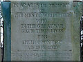
War Memorial Inscription
The inscription on Image] reads:
IN GRATEFUL MEMORY
OF
THE MEN OF WHITEFIELD
WHO
IN THE GREAT WAR
GAVE THEIR LIVES
FOR
THEIR COUNTRY
AD 1914 - 1918
"THEIR NAME LIVETH FOR EVERMORE"
ECCLESIASTICUS XLIV.14
Image: © David Dixon
Taken: 23 Dec 2012
0.07 miles
10
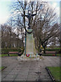
Whitefield War Memorial
The War memorial and memorial garden on Higher Lane. Behind the memorial is All Saints Parish Church and its graveyard.
The inscription on the memorial reads:
IN GRATEFUL MEMORY
OF
THE MEN OF WHITEFIELD
WHO
IN THE GREAT WAR
GAVE THEIR LIVES
FOR
THEIR COUNTRY
AD 1914 - 1918
"THEIR NAME LIVETH FOR EVERMORE"
ECCLESIASTICUS XLIV.14
Image]
Image: © David Dixon
Taken: 23 Dec 2012
0.07 miles