IMAGES TAKEN NEAR TO
Higher Lane, MANCHESTER, M45 7UZ
Introduction
This page details the photographs taken nearby to Higher Lane, M45 7UZ by members of the Geograph project.
The Geograph project started in 2005 with the aim of publishing, organising and preserving representative images for every square kilometre of Great Britain, Ireland and the Isle of Man.

There are currently over 7.5m images from over14,400 individuals and you can help contribute to the project by visiting https://www.geograph.org.uk
Image Map
Images are licensed for reuse under creativecommons.org/licenses/by-sa/2.0
Notes
- Clicking on the map will re-center to the selected point.
- The higher the marker number, the further away the image location is from the centre of the postcode.
Image Listing (59 Images Found)
Images are licensed for reuse under creativecommons.org/licenses/by-sa/2.0
Image
Details
Distance
1
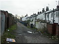
Whitefield, back lane
Shared by York Street Image and Livsey Street. Back lanes rarely look as well-maintained as streets, but are just as public.
Image: © Mike Faherty
Taken: 26 Jan 2009
0.01 miles
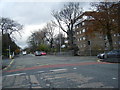
3
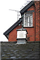
House on Pinfold Lane, Whitefield
Clock tower and weather vane on the garage roof.
Image: © michael ely
Taken: 17 Mar 2012
0.04 miles
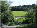
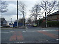
5
Pinfold Lane, Whitefield
Looking from outside Whitefield library towards the junction with the A635, Higher Lane.
Image: © michael ely
Taken: 17 Mar 2012
0.07 miles
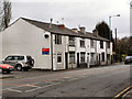
6
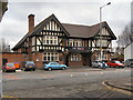
Eagle and Child
Higher Lane, Whitefield.
Image: © David Dixon
Taken: 6 Mar 2010
0.09 miles
9
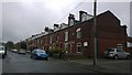
Egerton Road, Whitefield
Red-brick terraced houses line Egerton Road in Whitefield, Greater Manchester, England.
Image: © Steven Haslington
Taken: 15 Apr 2015
0.11 miles
10
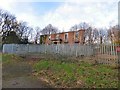
Former Whitefield Town Hall
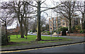
The building was built around 1805 by Edward Barlow and originally named Green Hill. It was remodelled in 1857 and renamed Underlay. It became Whitefield Town Hall in 1933 until 1974. http://www.oocities.org/whitefieldudc/town-hall.html Since being vacated in the 1980s, it has been set on fire, vandalised and partly demolished. Only the south facade remains. Plans for a care home on the site have hung in the air for many years without resolution.
Image: © Gerald England
Taken: 29 Dec 2018
0.11 miles